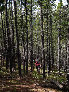
Alf's directions were pretty good, to a point. That point was the ridge 250 m above the road. The trail is as he called it: flagged occasionally, blazed occasionally, cairned occasionally (the cairns are the least useful guide). While almost straight up a 27° slope, it's OK to follow, though it seemed to me easiest to just look for the route cleared of lower branches, as that was more distinctive than the blazes, cairns or flags.
 |
| KC on trail. Note the blaze on the tree next to her |
 |
| Purple |
 |
| Looking WNW |
 |
| A streamlet. Note the flagging on the right. |
 |
| Powderface Outlier on the left. Cornwall, Glasgow & Banded Peaks. |
 |
| Prairie Mountain |
 |
| The city of Calgary |
 |
| The peaks |
 |
| A puppy had played here |
We thought about climbing the Powderface Outlier as we had back in 2008, but changed our minds. Instead, on our way down wia the Powderface Creek trail, we played Civil Engineers. There are many, many springs cutting across the trail, turning it into a river in spots. We cut drainage ditches in at least 8 places to drain the water off the trail as we went down.
 |
| Creek flowing across the trail |
 |
| Another, re-directed |
 |
| A long creek/trail section |
 |
| A big puddle by a spring before we got it to drain |
 |
| The trail = the creek. Explaining why it is called Trail Creek |
Which leads me to my next post. Stay tuned.


No comments:
Post a Comment