Friday 11 May 2018

Castles and forts

Now officially a week behind in blogging...

One of the things I pre-planned for this trip was doing local bike tours from Amsterdam. I found them on holland-cycling.com, confirmed them on the cycle planning site hollandcyclingroutes.com, and followed them on the bike using the free Fietsknoop app.

I did a bunch of research in advance on finding inexpensive longer term bike rentals; we were planning to rent the bikes and keep them for at least 3 days. In truth, only about 10% of the places you can rent bikes in Amsterdam have an on-line presence. Cheapest of these was Mike's. After a bit of checking, I still think Mike's were a good deal; we paid €46 for two 7 speed bikes for 3 days.
Our steeds in the shop at pickup
The forecast was for 3 days of near perfect cycling weather, with limited wind and temps in the high teens. For Day 1, I picked the longest of the routes, and we ended up biking 61.3 km in just under 8.5 hrs with lots of stops. Our route went down the Amstel River and toured the old fortification line of Amsterdam, a series of forts built in the late 1800's and abandoned at the start of WW1.
Our route
Riding in Amsterdam isn't much fun; the farther away from Central Station you get, the better it gets. Initial navigation was pretty easy; follow the Amstel river. 
A typical path as you head out of Amsterdam
Virtually all of the bike routes in the Netherlands are paved. All the long distance ones are marked like they are in Belgium with intersection numbers. The numbers are not locations but where paths connect. You simply have to play connect the dots. While riding, it's allegedly as easy as following the direction signs to the next numbers, but we learned over the 3 days that it's just not that simple. Not all pathway intersections are signed, not all signs are in the right places, not all signs are visible, some are confusing, so the Fietsknoop app is essential because you WILL get off course. We did, several times.

The Amstel River is fairly big and slow moving, so full of rowers. There are also a few windmills around. Most are "polder mills" the ones built to pump water out of the polder to keep the land dry.
On the other side
On our side
Around here, we had an "incident". Karen was trying to take a picture while riding (a no-no, but there you go). We came across an ill-marked intersection and I slowed to check the map. Paying attention to her picture instead of riding, Karen tried to stop suddenly, wiping out on her bike, and putting a 6" gash in her shin. On the bright side, she was carrying some Purel and a handful of bandaids. Bandaged and bruised, we continued.

As we got further south, we left the Amstel River and, as is the case in this area of the Netherlands, crossed canal after canal. We ended up in this little town...
Note all the bike direction signs 
The pretty view of the church from the other side
...and while we were stopped taking pictures, this dude came up on a scooter, put the bridge gates down, and raised the bridge by hand with a crank so a boat could go through -- then lowered the bridge again and drove off.
Going up 
Dude a 'crankin' 
The boat sails through
We rode about 15 minutes further and, sure enough, while paused, it happened again.
Lady arrives to unlock the bridge 
The gates are lowered 
The bridge is up 
The boat comes through 
The bridge goes down
This bridge was electric, not manual; she cheated. Around here, we also learned that just like the bike network, the canals have intersection points, too - I think they're called boatknoops (you can see a sign in the lower right of the last pic above). There's a walking trail system in the country, too, that works on the same point-to-point system.

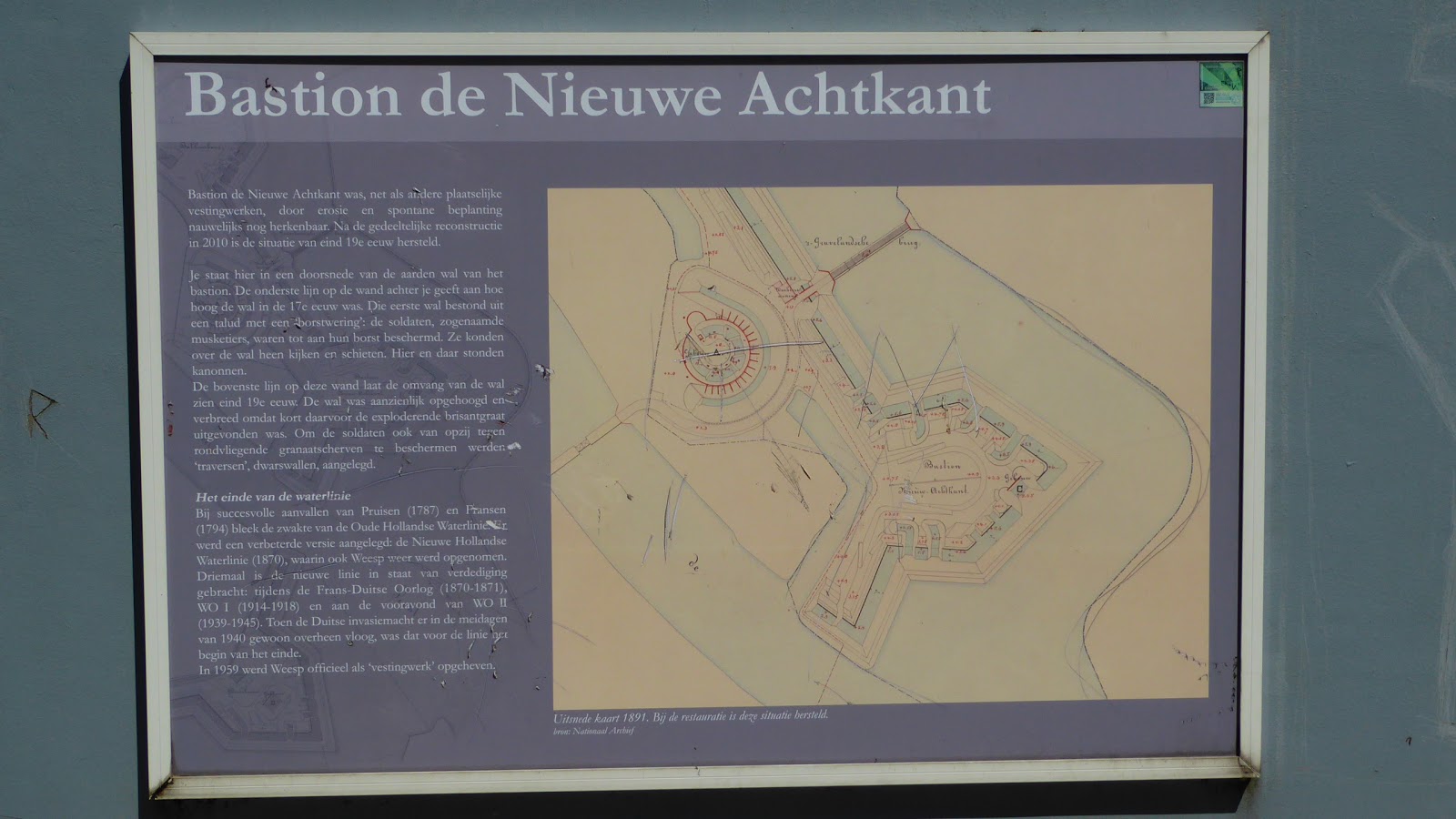
Not much further, at about the 20 km mark, we found our first fort, though there's little of it left.
It used to be on that island
Back in the 1800's, they had a great idea to protect the capital of Amsterdam by doing what the Dutch do best: control the water. They encircled the city about 30 km away with a series of small forts on high ground. They created a system of dykes and canals  that, if opened, would flood the land between the forts. Not that deep, but this was the era of armies on horseback. A great system, when it worked. Not so good in winter (the water freezes), not so good when WW1 begat airplanes that could fly over it, not so good when the land took too long to flood to stop the oncoming army (all of which happened).

Along the way, we crossed the major shipping canal through this section of the country.
Not a small boat at all
We passed through the pretty little town of Weesp.
A classic Dutch scene 
The "main drag" 
Canal houses here
We of course got stopped by a bridge going up.
Waiting 
The boat passes
The fort here is still in use -- privately owned, it's home to an architecture/design firm.
You are here
Not a bad way to guard your business 
It's circular
Does this photo make it look fat?
The fort here has star pointed bastions on either side. The one side is a park, the other side has houses built on it.
The plan. Circular fort in the centre
Bits of remaining bastion wall 
The detail 
Looking our the remains of the bastion walls
Just up the canal from this fort were two photogenic windmills.
Seen over the bastions 
Elegant 
I swear they're posing 
An artistic but accidental shot by KC
In addition to having a picnic there, we walked through the town, with it's stately church...
The backside, as we approached 
The frontside
...the violin making shop...
Not a common site
...and the folks taking their kids on horseback through the streets.
Why not, I say.
Waiting for the bridge, like everyone else
In front of the fort here, by the way, was the WW2 memorial for the town's residents.
Simple
The plaque on the left lists the names lost. ~80% died in Auchwitz, Sobibor or Bergen-Belsen.

On we rode, to the toal highlight of the day: the Muiderslot fortress. At the entrance to a main canal, right on the (then) Zuiderzee, now run by the Rijksmuseum.
Shades of Monty Python
Built initially in the 1200's, rebuilt in the 1300's, 30 m on each side, 25 m tall, it was a medieval heaven with towers to explore, dungeons to see, drawbridges, games to play inside, armour to wear, chain mail to try on, and one of the coolest bathrooms I've been in in a long time (no photos of those, however).

Medieval, alright 
Nice moat 
The inner courtyard 
The sentry walk walls 
Arrow position details 
Stairs in a tower 
Leg irons, anyone? 
Karen as a damsel 
Me as a jester 
Armaments, armour, and all the good stuff
From the back side
There was a pretty little garden inside the grounds.
Trellis entryway 
Center fountain 
One side flowers, one side veggies
There was a really interesting space on the grounds that described how the fort worked as a part of the Amsterdam defence line, but it dwelt with the idea of water as "friend or foe". It was set in one of the old fort bastions and was ultra modern.
Down below is the exhibit
At the end of a brief film on how the defence line worked, an entire waterfall started that lasted 3 minutes. It started with a gap in it, so I went through.
Mee shooting on the other side of the water wall 
The gap is clearly visible
Then the gap closed. Water trapped me in the space.
'Aint no gap now 
Karen shooting my predicament 
That's me, behind the wall of water
Very cool interactive display.

Alas, it was time to walk around the fort and ride home. Muiderslot's expensive to visit, but well worth it.
Still Python-esque 
From the rampart 
Fun spot
Not far from the Muiderslot, we also found this gun emplacement.
Also part of the system 
They liked round forts
The ride home from here took about an hour, so it's really not far from Amsterdam, nor is it hard to find.

Aside from Karen crashing and injuring herself, it was a spectacular day for a ride, and having the Muiderslot Castle near the end was a real highlight.

Next up: You can pay €50 to go on a tour to Zaans Schans. We rode there in about 90 minutes, for free.

No comments: