Sunday, 14 July 2013

Flood Recovery

As has the rest of the valley where I live, we have been busy with flood recovery for the last few weeks, first with our house and then with our neighbourhood.

Step 1 of our recovery process was getting the bad wallboard removed our house dried out, which I wrote about here. This past week, the MD finally brought a dumpster around to the hamlet to handle building waste, so KC loaded it while I was off doing other stuff.
Car full of crap. Load 1 
Load 2
Step 2 of the recovery process, interestingly enough, was the seeding of our back yard. Part of the reason we had some of our flood issues was that we had just finished re-sculpting the yard to improve drainage (as I described here), but were left with only bare earth when it started raining. So we seeded the entire back yard in a sheep fescue grass which (a) is native (more or less), (b) requires no mowing, (c) grows in most any type of soil or dirt, and (d) is excellent at soil stabilization.

On June 28, we hand raked the entire back yard (all 3,000 square feet of it), hand seeded it, and then hand raked it again.
2/3rds raked 
KC hard at work 
Re-raking after seeding
Since then, every day we have watered the dirt 3-4 times a day, keeping it moist. Our first green bits showed up last week, and as of today (16 days later), there's a lot of green dirt.
1" tall 
Looking promising 
Greener than the above seeding shot
Step 3 was to get our water well tested. We failed. We have e-coli and colliform bacteria in the water. Best bet is that it came from from sewage runoff from our neighbour who's septic system backed up during the heavy rain, flowed over their yard, down the alley and across our yard. So we shocked our well (dumping a LOT of chlorine in it, then circulating it through the system), and await the results of a new water quality test that we will do tomorrow.

I hate bottle water as a concept; an environmental nightmare. But there are times when it's useful. Now is one of those times. I am, however, hugely tired of it, having had nothing but bottled water to drink since June 21.

Step 4 was to get in a contractor to arrange the re-laying of the paving stones. We got one to show up, but he hasn't offered up a bid yet. So that portion of the yard is still a dirt pit.

Step 5 was to get an insurance adjustor in to assess the basement damage prior to starting the re-building process. He showed up, took a look, and told us we were not insured at all. This wasn't that bothersome to me. Had we been insured, the deductible was $1,000, and I was sure the re-build materials would be much less than that (to date we've spent ~$250 and need little more to finish, but more on this in a moment). We're still going to file a claim for uninsured loss to the Disaster Assistance Plan.

With that cleared up, Step 6 was to start the rebuilding. On July 9, we got all the drywall we needed, screws, a dimpler to drive in drywall screws, and set to work. KC was amazed at the drywall cutting process (score the paper with a knife, snap it off).
9 sheets on the roof 
The first of the boards 
4' sheets
So for the better part of 4 beautiful, sunny summer days days, we stayed in the basement and hung boards. Most had to be cut to weird shapes. Lots of small bits were needed.
Hall bits 
Vent holes
We discovered that some of our wall studs -- make that many of our wall studs -- are just not square. Or straight.
Two major gaps we will have to deal with when we mud
Working around the base of the stairs required creative effort.
Couldn't slide in one board here 
Or here. But couldn't cut this one in two either
But as of yesterday, the boards are all up. Next step in this process: Mudding, taping and sanding. Then comes baseboard & casing (which we haven't bought yet). Then comes painting (and we haven't purchased the paint yet, either). And a deadline. We have guests coming July 26th, and have to finish the basement -- or at least the bedroom down there -- by then. Wish us luck.

But we can't just stay focused on our house. So as Step 7, KC and I both volunteered this week at other duties. KC ran a dinner in her capacity as President of the Networking Environment for Women, did some grizzly camera work...
This picture is NOT tilted. The bridge is listing, the tree bent
...and tried to come fix trails with me (but was rained out).

Me? I met with folks about donating to the Friends of Kananaskis to help re-build trails, spent a day working on a trail, gave an interview to two local papers regarding our support of Parks during the reconstruction process.

My trail work was a toughie: pulling out a huge log jam on the Heart Creek Trail. We made the Calgary Herald. That's me, 2nd from the right, in the photo.
Photo by Craig Douce
In all, over 75 people worked on that trail last week, and an additional 100 or so worked this weekend, plus the awesome Parks crew -- probably 1,400 hrs put in to that one trail. Here's two really crappy iPhone photos of the mess that took 6 of us all day to remove.
About 10' high, forming a waterfall 
The restored bridge
Here's another Craig Douce/Herald photo of me hauling a log we pulled out.
I was sure someone was going to fall off that bridge
This is what it looked like when we were done.
Better. But still work to do.
It's been a busy few weeks. It will be a busy summer.

Friday, 5 July 2013

Going where you can't

As a volunteer with Alberta Parks, I'm right now allowed into places a Ministerial Order prevents people from going. In this case, it's because I'm working the grizzly bear project. Today, I got to go south of the Wedge Pond closure on Highway 40, down all the way to Peter Lougheed Provincial Park.

Much of this post I put up without photos today on the Kananaskis blog, an excellent site for news and info about Kananaskis.

Highway 40 is closed at Wedge Pond, with a single lane bride over Evans-Thomas creek.
The one lane bridge
The bike bridge is still there. We crossed it in 2011. But so what? It starts in the middle of nowhere, ends nowhere, and the creek currently runs around it, not under it.
The bridge to nowhere
Once past the Wedge Pond roadblock, crews are working hard on the road washouts...
Much work 
Lots of stuff to get rid of

...with the biggest crews (multiple backhoes and dump trucks) working the mess at Grizzly Creek, Ripple Rock Creek and Hood Creek...
That's the new channel of Hood Creek
...where the pavement was removed in numerous places and hundreds of tons of debris hit the road.
Debris on the Road
The road's looking really good, but needs more time. There's also a huge mess spanning from Opal Day Use north to Galatea. Numerous hillsides also slumped and put debris on the road but these have mostly been fixed.

South of Hood Creek all the way to the North Interlakes, the roads are fine. Parks staff is escorting people in and out to get vehicles stranded back there (Boulton Trading Post has ~15 RVs and 5 pickup trucks awaiting retrieval).

So, to the trails: Starting at the Interlakes...
Looking back across Lower Kananaskis Lake
...we walked the Three Isle Lake trail to past Invincible Creek.
The Upper Lake level is surprising low 
Down the Aster Lake Valley
Across the lake to Mt. Sarrail & Foch
The trail's fine until the bridge over Invincible, which is still there, but is under 2' of water, and is now the top of a very pretty waterfall.
The bridge 
Yes, that's the bridge under that
The creek is still roaring, and was probably 100' wide during the peak of the flood.
Bridge approach. Note the sign on the right
There's a very dangerous way to cross the torrent on a log jamb. I did it twice and can't really recommend it.
The mess that is the crossing
Someone else was back there on a bike today. I hope it was a Parks person.
What is that? AND it's locked up!
Headed back down the moonscape of the Palliser slide...

...and went past the Point campground, which looks OK (though we didn't go in). In the forest, we found a boreal toad, who despite being slightly "poisonous", is quite cute.
Cute dude
Crossed the Kananaskis on the still-intact-but-listing bridge at Lower Kananaskis Falls (the river still runs under one end, which I hope won't cause it to wash away).
Bent. Not in a good way, either
The river is still in full flood and has partially eroded the bank with the trail on it. The trail here was under water and shows the effects of that.
Mud on the "trail" 
Bank erosion
Lower Kananaskis Falls. Bridge at the top
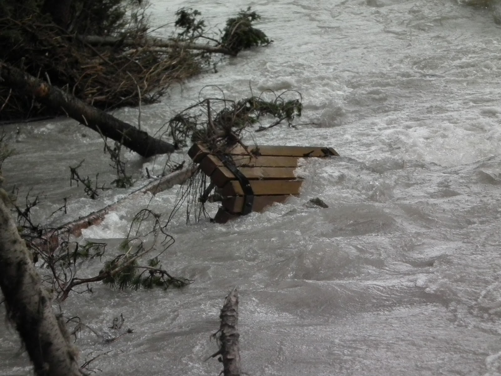
Wherever it was before, the memorial bench is now stuck in the middle of the river.
Not a good place for a bench
The wildlife seems to like the fact that we're not there. On the trail, saw multiple recent bear scat and tracks...
Poop #1 
Poop #2 
VERY large grizzly footprint
...recent wolf and coyote scat, recent moose tracks and scat. I also saw a moose near the Pocaterra Day Use area, but she would not hold still.
Her back 
Enlarge the picture; there's a face on the right
My time back there today really hammers home that there are parts of the backcountry that are just fine, but the parts that aren't safe are really not safe. I was in a meeting with Parks this past week where they ran through a quick inventory of the damage, and while it's not my place to disclose the discussion in that meeting, it's pretty safe to say that almost all bridges are damaged or gone, and trails in low lying or narrow creek valleys are very badly damaged. Trailheads and parking lots are missing or filled with rock. Creeks are still rivers, and rivers are raging. While some places made it through unscathed, you may not recognize some places when you get there next.

I have spent little time in this area, and had only hiked these trails once, many, many years ago. It's a very cool space that I must come back to.

Tuesday, 2 July 2013

Climbing and baking

Weary of tearing basements apart and getting rid of water damage, we decided we needed a break. We also realized that we hadn't actually gone out for a proper hike in a while. So, where to go? Much of the Kananasksis area including virtually every road access is closed due to all the flooding of last week. One hike that is accessible is Mount Lady MacDonald, which we last climbed back in October, 2011. It's bigger and more ornery that we really wanted as a season opener, but it's what's available.

So up we went on Canada Day, a day that turned out to be the hottest day of the year. It was 24° at 10:30 AM when we started walking, 29° at the top up 880 m (2,890') at 2 PM, and 33° back at the car at 5 PM.

There's lots to like about this hike -- with the best being the increasingly good views as you climb -- but it is indeed a relentlessly steep uphill slog.

There were a couple of spots to see the destruction wrought by the floods.
Red house dangles 
And this is after it has been partially cleared up
You can't park at the "normal" trailhead; that parking lot has been washed down to Calgary. Instead we parked up in Silvertip and got to the trail via the Montane Traverse.


Given that it was Canada Day, all the way up we could hear marching bands playing, which is an interesting way to be in the wilderness.
The parade's down there 
KC and Monty take one of many, many breaks 
Looking up into Banff 
The Town of Canmore below. Didn't look like this last week. 
The Three Sisters
As usual, we quit at the soon-to-be-demolished tea house and helipad. At least 5 others continued the additional 300 vertical meters to the dangerous knife edge ridge and the summit.
4 people in this photo; 2 on the summit, 2 on the right ridge
Given how much is closed, it was busy on the trail. We ran into a total of 12 people coming down who had camped up there overnight, a guy going up to camp, a pair of mountain bikers working their way up (camping and mountain biking are illegal on this trail) -- and a paraglider heading up to launch from the helipad.

Not much wildlife today. Too hot for the pikas to be out. One lone visit from a Golden Mantled Ground Squirrel who tried to steal my lunch.
Surveying his domain 
Getting mad at a dog
The last time we did this hike it was only about 15° and sunny, and we made it up in 90 min. This time it took 2.5 hrs to get up. I blame the heat. Being the first hike of the season had nothing to do with it.