Sunday, 5 August 2012

Helen Lake Ridgewalking

On a warm and sunny August long weekend Saturday, there must have been 75-100 people up wandering around the Helen Lake area, including at least 30 people summiting Cirque Peak. And why the heck not? Not a cloud in the sky, and we left the heat down in the valley.


There's a lot of similarities to the hike up to Rockbound Lake behind Castle Mountain: a moderately long saunter up to a lake in a big glacial basin. But this hike is better, in that it gets into the open in 3 km instead of 7 km, gets to the start of the area to explore in 7 km instead of 9 km, and offers a lot more in the way of low energy exploring.


The beginning 3 km of roots and mud (at least half a dozen small creeks need to be hopped) aren't that interesting, and don't offer much in the way of views. Still, you get the occasional glimpse of Crowfoot Glacier...
Looks more like a glacier in the summer
...and there's not that much in the way of grunting up steepness. The place was riotous with wildflowers, many of which seem to be the favoured snack of the dozens of resident marmots.
Munching on Indian Paintbrush
Once up high, the views are pretty stellar. 
Creeks in the basin 
Helen Lake. Cirque Peak rises above
We ate lunch on the cliff edge on the headwall above Helen Lake, accompanied by columbian ground squirrels...
Watching us
...and a marmot who at one point wandered within a foot of us (I don't think he noticed us until he almost stepped on my daypack).
Fuzzy face, up close
We thought seriously about attempting to climb up Cirque Peak. However, two things turned us back: (1) we're lazy, and (2) the normal ramp route was blocked by a snow patch, necessitating a scramble that (from a distance) didn't turn our cranks.
Cirque. The ramp up the right blocked by snow. You gotta climb cliffs 
Two folks climbing the cliffs
Still, we counted 25 people on the mountain at one point, and saw two other parties heading that way, so it's not that it isn't doable.


Instead, we decided to wander past Katherine Lake and over to Dolomite Pass.
Dolomite Pass in the distance 
Katherine Lake under Mt. Dolomite
Katherine up close
The trail to Dolomite Pass crosses the creek feeding Katherine Lake. Today, that inlet was a slow flowing creek that was at least knee deep. 
Wide, deep and cold, to boot
Rather than wade, we struck off cross country through occasionally gravelly, occasionally grassy, occasionally boggy meadow and went around the creek to a place where we could hop across it.
Looking back after crossing. We crossed just off the right side
Ordinarily, you're supposed to stay on trails especially in the high alpine. But if you scatter out, tread carefully (no walking on moss campion, for instance), try to stay on rocks, you can wander around without doing much damage.


Dolomite Pass isn't much to look at. You can't see down into the valley of Dolomite Creek. You can see big mountains across it and around ther creek's headwaters.
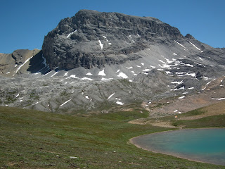
An unnamed lake. Note the two tents 
KC at the pass
Looking back. Cirque Peak on the right. Helen Lake over the ridge
Yes, there were two tents at the little lake at the pass. No, camping is not allowed here. Yes, I reported it to Banff Dispatch (along with the bear we saw on the road up) later in the day.


On our way back, we decided to climb and walk the ridge.
We're aiming for the left side of the ridge
We came across a set of 10 metal posts in the ground, part of a research project, I'm betting. On what, who knows?
Numbered 1-10 
KC ascending. Dolomite Pass in the background 
Looking up the ridge. Cirque Peak peeks above it on the right.
Climbing to the high point
I don't know if the trek to Dolomite Pass was worth it, but the ridge sure was the high point of the day, elevation-wise and otherwise.
The trail up skirts the treeline on the left. Crowfoot Glacier upper left 
Helen Lake
It was such a clear day today, you could easily see Mt. Assiniboine, which is a mere 70 km away.
Way down the valley sits... 
Mt. Assiniboine
On our way home we couldn't help but look back at our accomplishments...
Cirque Peak and our ridge
...and notice the surreal clouds that had moved in on us.
Lennies over Cirque
This was a fun hike, though suffering from the worst trail braiding I had seen in a while.
Not tire tracks. Not bike tracks. People tracks.
All in all, we wandered 21.4 km and climbed a total of 865 m.
Our route in GoogleEarth

1 comment:

Edwin said...

That Lennies over Cirque picture is probably the best picture ever to be featured in your blog. Absolutely love it!