Monday 31 August 2015

Foiled again

Last week, we tried to go to Commonwealth Valley, a hike you bike into, with great views and high alpine meadows. But we hadn't made it more than 2 km from our house when the smoke and terrible viz turned us away.

Yesterday, the forecast was calling for sunshine, some clouds and windy today, and rain coming in later in the week. The smoke is mostly gone (though it could come back; the fires aren't out yet), so we planned to hit Commonwealth today before the rain hit.

This morning, it was partially overcast but OK in the valley. We strapped the bikes on the car, drove 50 km down the Spray Valley to the Commonwealth trailhead, and found...

Rain. It was sort of sunny in the northern section of the Spray Valley, but the farther south we got, the worse it got. The Commonwealth Valley itself was grey, and the farther up the valley you looked, the more socked in it was. So much for the forecast. And so much for hiking in.

We thought we might just move a few valleys north and bike in to Watridge Lake (which I last rode to in 2009), so drove to the Mt. Shark parking lot. That valley was no better, and it was spitting rain, but we could see it was still sunny with partially blue skies back up where we started in the northern section of the Spray Valley.

So we drove back to the Spray West campground, thinking we would ride the 28 km round trip West Spray Road (which we last did in August 2011). Then Karen had a bright idea to instead ride north towards the Goat Creek parking lot along the old power-line service road that they are turning into the High Rockies Trail in this area. Sure enough, we found trail crew stuff, but the crews themselves weren't working.
Trucks, quads, gear & wood 
Boardwalks under construction 
The boardwalks start at the far end of the road
The reason they're building boardwalks is because it's quite marshy in that area. We couldn't see a good way through the marsh, so after having ridden all of 2.3 km, we pulled a U turn, intent on heading back to the car, then back to the West Spray Road.

And right around here, the saddle on my bike broke. A clamp that holds the nose of the seat down failed. My seat was thus unstable, and my bike sort of unrideable for any distance. So much for riding anywhere today.

So it was back to the car...
Spray Lakes Dam, where we parked 
Little Lougheed and cap clouds on Mt. Sparrowhawk
... then back to town. We stopped at a bike shop who concluded that they don't make replacement parts for things like that (because they "never break"). With them, I brainstormed ideas on how to fix it, then went to Canadian Tire and picked up some clamps designed for electrical conduit. A bit of reaming to make the hole big enough for the seat bolt and bingo, problem solved.

So we spent 3 hrs driving around in the car to ride less than 5 km, saw 2 deer, and once again proved that weather forecasts in the mountains are useless. I wonder if we will get into Commonwealth this year?

Friday 28 August 2015

Avoiding the smoke

So this whole "try to post stuff in order" thing isn't working. Catchup is slow. So now you get current events merged with random older events.

The weather this week has been strange. We had cold and snow on Saturday...
Lots of white
...which became warm and sunny on Sunday (meaning the snow was mostly gone by Sunday night). Then on Monday, the smoke from the terrible fires in Washington State and southern BC arrived. At times it was so thick, you couldn't see across the valley. You could stare into the sun because it was just an orange blob.
The sun behind the mountain 
Yes, those are visible sunspots
We were planning to hike Monday but the smoke was so thick and it smelled so bad, we bailed. We were supposed to help the Stewards tear apart illegal bike structures on Tuesday, but there was a health warning out for the air, so Parks cancelled it. We were supposed to do camera work on Wednesday but the health warning was still in place and it was cancelled by Parks Ecology.

So we sat inside, doing very little, for 3 days. I worked on a new album. Karen cleaned. I cleaned. I tried to seal up more mouse holes. Karen sewed. But after 3 days, we had cabin fever. We HAD to go out and do something.

We looked at the smoke forecast and came to the conclusion that by going north we would get out of the worst of it. I looked and decided to drive a bit over 2 hrs north to Parker Ridge, the most northerly hike in Banff Park, on the south end of the Columbia Icefield. A shorter hike of only about 6 km with only about 280 m of height gain, I figured we would only be hiking 2-3 hrs for 4.5 hrs driving, but it was better than nothing.

We left a socked in valley at 9 AM, barely able to make out the mountains on either side in an orange haze. By Lake Louise, it hadn't improved much. By Bow Lake and Bow Summit, it was much better, and we even thought about just heading to Bow Glacier Falls. But we soldiered on. North of Saskatchewan River Crossing, it was better still, and by the Big Hill, there were sheep on the roads causing traffic jams.
Sheep on the side of the road 
Dumb tourists out of their cars
We left the house at 9 and were on the trail by 11:30.
Ah. Basically smoke free.
While you can't see the Athabasca Glacier from here, you can see Mt. Athabasca and it's north glaciers.
People climb that pretty much every day
The view across the valley of the Nigel River valley is nice. There's a long trail up that valley that apparently has good views.
Road 200 m below
The east-west ridge is serious high alpine terrain, windswept and fragile. The popularity of the trail causes people to shortcut it, creating braids that Parks tries to control.
The high windswept stuff
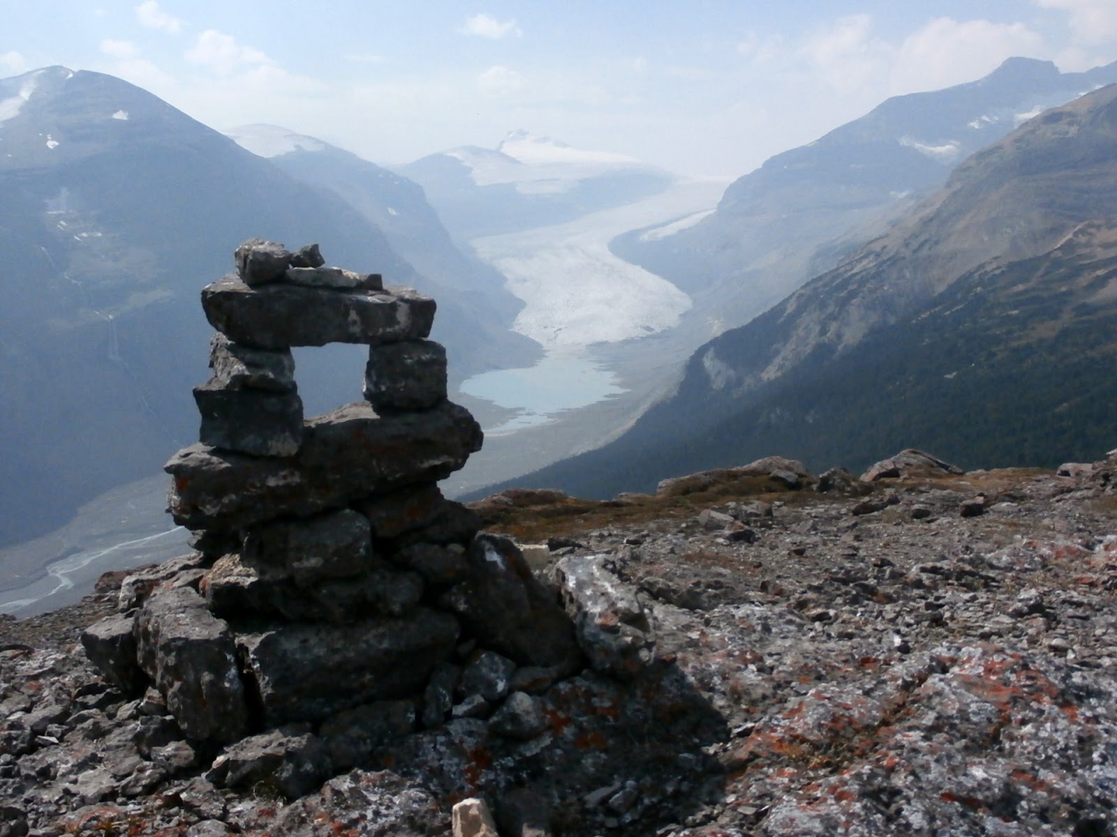
The prize for most people on the trail is the view of the 13 km long Saskatchewan Glacier, the largest outflow of the Columbia Icefield.
Hazy but nice
Parker Ridge is basically flattish. It rises ~100 m in each direction from the saddle the trail heads up. So we wandered up towards the west knoll, which is covered in cool rocks with quartz crystal-filled worm burrows.
Very cool 
Some are more "quartzy" than others
The views from the hilltop are nice.
Lennies over the Nigel valley 
You can easily climb this next hill, too. Look carefully... notes below 
Looking back to the east peak 
Looking up the valley towards Wilcox Pass and the icefields
If you look VERY carefully in the photo 3 above, you can see critters. A herd of sheep was hanging out, with a big ram sheep watching over them.
Three of the 9 
The dude on the ridge 
That spec is the dude
And if you look carefully below the dude on the side of the slope above the snow, you'll see 4 hikers who deviated off the trail to walk around the dude, who was in no mood to give way.

The east knoll looked like fun, so we climbed it, too.
The glacier and it's terminal tarn 
I think someone has been here before 
A barren place 
Looking southwest down the valley 
Mt. Athabasca looms larger. West knoll is the bump on the lower right
And yes, it's fall up here.
Avens turned red 
Willows turning yellow
On our way home, Karen revealed that she had never been to Mistaya Canyon, where the Peyto River drops through a narrow slot canyon, which is a 5 min walk off the highway. Had to stop.
The start of the slot 
Broad
In 40 m, the river has dropped 40 m into the 5 m wide canyon
50 m down to the swirling, churning water
On our way home, the smoke started socking in just after Bow Lake. Lake Louise wasn't too bad; Banff was almost okay but stinky -- but the valley near Canmore was orange soup with ½ mi visibility.

Glad we escaped to good air.

Tuesday 18 August 2015

July 6: Stupidly going to West Wind Pass

We were idiots on July 6. We woke to a beautiful morning, perfect for hiking, and spontaneously decided to head up to West Wind Pass for a picnic.

Except we should have taken a look at our calendar first. We had invited people over for lunch that day. So while were sitting on the top of a mountain enjoying the day, the great views, and our fabulous picnic, our guests were at our house wondering where we were, phoning and texting us.

Duh. Is that a senior moment?

It had been a while since we were up West Wind, one of our favourite places and a hike we send people to all the time. The views haven't changed...
On the way up. Mt. Nestor is the peak with the snow patch 
Nearing the top 
Looking up at the Rimwall 
Karen arriving at the pass 
Wind Ridge 
The Rimwall from the pass
Looking back at Goat Mtn.
...but the trail has changed a bit. Never official, it was always subject to a bit of braiding. There was a "lower trail" section that featured a harder crossing of a rather sheer rock face. Now someone has built a high bypass over that rock face (and marked it with red painted arrows!) that's far more dangerous and not recommended over the main trail marked with a cairn (plus, if you do go up there, any rock you kick off will come crashing down on people on the main or lower trails). There are other unmarked trails that split off to ascend the Rimwall. Newbies to the trail will hit junctions and not know what to do. Even Gillean's guidebook doesn't come close to describing all the new stuff.

In addition, a LOT more trails have appeared on the scree below the Windtower. I always thought these game trails. Maybe not.
Look at all the goat trails!
As we hit the bottom of the trail we ran into the construction crews on Day 1 of trail building for the High Rockies Trail, which crosses the West Wind Pass trail near the road. I don't think this cross trail will confuse anyone heading to the pass.

We finally realized we were stupid and had invited guests over around 3:00 pm when we got back into cell range and got their texts and phone messages. We sent flowers and apologies.

But we were still stupid.

Monday 17 August 2015

New start to Centennial & Wind Valley/Ridge Trails

I was up doing some volunteer work today at the Wind Valley trail head above Dead Man's Flats. This is the northern starting point for the trails up Skogan Pass, Pigeon Mountain, Centennial Ridge, Wind Ridge and the Wind Valley.

The 2013 floods washed out all the bridges at the start that lead to Centennial Ridge, Wind Ridge and the Wind Valley (the floods may have blown other bridges up higher, but I haven't been up to look). Post flood access to these three areas involved a small rock hop over Pigeon Creek (the first smaller creek you come to, about 300 m from the parking lot) and a more complicated crossing of the larger Wind Creek. The Centennial trail heads up between the two creeks.

In the last few weeks, Alberta Parks trail crews have done a re-route of the trail and put in a new bridge over Pigeon Creek. The re-route kicks off right near the old washed out bridge location...
Old road to the right now blocked. New trail to left marked with blue post
...heads upstream ~50 m, and crosses a a brand new bridge.
Bridge looking west 
From the other side
Once across the bridge and creek washout, you immediately arrive at a T intersection. Left is Centennial. Right is towards Wind Creek.
Arriving at the T 
Looking toward the Centennial trail
I'm betting the bridge was put in because Centennial is an official trail. However, the Wind Valley trails are not. Because if you turn right at the T and head towards Wind, in 50 m you'll first pass the old and now closed off trail where the road used to be (and rock hop of Pigeon Creek still is)...
Looking back across Pigeon Creek at the old trail
...then arrive at the wide washout of Wind Creek, where no bridge has been built to replace the once lost in the floods. Instead, to get across Wind Creek, you have two options.

Option 1: Turn left on a path through the trees for 25 m. Drop into the rocky creek bed. Arrive at a natural set of flood deadfall that has been enhanced with two cut logs that have been nailed in place. Cross the creek on these two logs.

Crossing on the high log. The lower logs also work.
Option 2: Drop the 5' bank into the creekbed gravel. Follow orange flagging across to the right to a dam someone had built. Cross on the 3 log bridge someone has built below the dam.

The dam 
The dam and the bridge