Thursday 28 June 2012

What does a Director direct?

Recently, I volunteered to be a Director of the Friends of Kananaskis. This is a not-for-profit group who's prime mandate is trail maintenance in Kananaskis Country.


I'm also a member of the Bow Valley Stewards, who's prime mandate is trail maintenance in Kananaskis Country.


Huh?


The Stewards work for Parks under the direction of a Conservation Officer. We do all sorts of jobs, including pull plants that bears use for food that grow in campgrounds, close trails that are in places they shouldn't be, track collared bears, ask fishermen about their catch, and the like.


The Friends are a non-profit organization with reps from Parks on the board including a Conservation Officer. After a few years without much focus (including doing such tasks as manning the retail outlets in the Kananaskis Visitors Centers and managing the Memorial Bench program), now the Friends mostly build new trails, maintain existing trails, and close unwanted trails.


Sensing overlap? I do. Part of the reason I volunteered to serve as a Director is that I see the overlap and want to do something about it.


Despite the overlaps, there are gaps. Best example: current trail conditions.


Alberta Parks updates the current conditions of hiking trails weekly. You can see it here. But:

  • Conditions change more often than weekly. A wicked day of bad weather or snow can change trail conditions fast.
  • They don't report on very many trails. Some of my favourites are in the Spray Valley. Parks mention Chester and Burstall and that's it. There are gaps all over.
  • They're wrong. A lot. They're warning this week about snow on Powderface and Jumpingpound summits. I was there today. There's no snow.
Part of the reason I write this blog is to post on current hiking conditions: a place for eyeball reports, like my Powderwatch.com blog on Sunshine ski conditions. I also submit trail reports to Gillean Daffern's website in the Forum section. But Gillean has been spammed a lot, and now insists on reviewing every post before it goes up. A few weeks ago, I posted on the status of a trail. The post was not released for at least 10 days. By the time it became visible, the report was meaningless.

So what is surprising to me is this: neither of the two organizations I belong to, who are full of folks who hike every day, encourage -- or even enable -- members to post current trail conditions. You can't get them anywhere that I know (and believe me, I have looked). Yet everyone wants them. The out of date, inaccurate and incomplete reports on the Parks site is it.

I'm sensing an opportunity. Are you?

So as a Director of the Friends of Kananaskis, I'm going to make it my goal to have a place where hikers can report conditions, and that these reports will be visible to the public. I want to promote the heck out of it. I want the Friends website to be the go-to place for the most up to date trail conditions, reported by the membership of folks who hike, mountain bike, and hang in my space -- just like Powderwatch.

Stay tuned. See how well I do at Directing.
North Powderface as a loop

Back when I lived in Calgary, one of my favourite short hikes was Powderface Ridge North. We were up twice within a month in September and October 2007. I recently saw on Gillean Daffern's blog that Alf Skrastins had found a loop route for this spot, and being a fan of exploring new trails and loop trails, we decided to give it a shot.


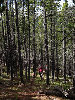
Alf's directions were pretty good, to a point. That point was the ridge 250 m above the road. The trail is as he called it: flagged occasionally, blazed occasionally, cairned occasionally (the cairns are the least useful guide). While almost straight up a 27° slope, it's OK to follow, though it seemed to me easiest to just look for the route cleared of lower branches, as that was more distinctive than the blazes, cairns or flags.
KC on trail. Note the blaze on the tree next to her
Karen found an orchid on the way up.
Purple
Part the way up, you start to get some stellar views, here of Compression Ridge.
Looking WNW
So getting to the ridgetop was fun, kinda like a bush bash without the bashing. At the top, the "trail" took a 90° right turn, led down a slope for 30 m, then made a 90° left turn across a slope into the forest where it crossed a stream.
A streamlet. Note the flagging on the right.
Unfortunately, the blazes, flagging and cairns stopped here. Alf's instructions were to follow the ridge to the open meadows, but buried in the forest, we couldn't see the open meadows. We continued gently uphill in a wide open forest until it became a 3' "cliff" of rusty rock and started to go downhill. Here we turned 90° right and bush bashed uphill through a weak forest across a couple of grassy bits until we popped out on the north end of Powderface Ridge. The view was glorious.
Powderface Outlier on the left. Cornwall, Glasgow & Banded Peaks. 
Prairie Mountain 
The city of Calgary
The peaks
There was a little patch of snow in the shady side of one of the cliff bands.
A puppy had played here
We had the place to ourselves save for 2 folks with a puppy that we saw at a distance.


We thought about climbing the Powderface Outlier as we had back in 2008, but changed our minds. Instead, on our way down wia the Powderface Creek trail, we played Civil Engineers. There are many, many springs cutting across the trail, turning it into a river in spots. We cut drainage ditches in at least 8 places to drain the water off the trail as we went down.
Creek flowing across the trail 
Another, re-directed 
A long creek/trail section 
A big puddle by a spring before we got it to drain
The trail = the creek. Explaining why it is called Trail Creek
We chose this hike today because all the reports said there was snow everywhere else we wanted to go. Methinks many of those reports are bogus. Yes, there is a LOT of water around. But the snow line sits above the 2,400' m mark.


Which leads me to my next post. Stay tuned.

Tuesday 26 June 2012

Desperately Seeking Septic

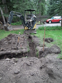
As I mentioned in this post, the MD decided we needed to locate our septic field. Today, my two contractors -- an engineering firm, and my general contractor -- came over to dig around to look for it.


The plan was to locate the outflow pipe at the septic tanks, then dig and trace it out. Most septic field run a main (non-weeping) pipe to T junction at a crossing header. The header then feeds a series of (weeping) laterals, which form a pattern kinda like this: Ⴤ (with the fluid flowing in from the bottom).


So our first step was to open the tank and look for the outflow pipe. Turns out its more than 7' down below grade, making digging down to it impractical. But it seemed to be heading off to the front yard, so we took a bee-line and dug a hole. And while we found the gas line first, we found a septic line buried 32" down.
Look for the white pipe in the lower right corner of the hole
So puzzle #1: Look at the pipe in the above photo. Run it straight back and it doesn't actually lead to the septic tanks, which are visible in the background.


The white pipe we found was not a weeping pipe, so wasn't a lateral. Probably. So we though we needed to go farther to find the header. And another hole was dug 40" deep on the pipe's trajectory into the yard.
Pipe in first hole. New hole in the upper right 
But we found no pipe. So we decided to start digging at the place where we found the pipe and follow it. It didn't do what we thought it would. It turned 45°, turned into black weeping pipe, and headed into the yard, always buried 32" deep.
Hole #2 filled in. 45° angle and trench
We still thought we needed to find a header so came to the conclusion we should continue exposing the weeping lateral pipe we had found. Around this time it started raining, and 2 (and sometime 3) dudes had taken 2 hrs to dig these small holes. My contractor concluded that we should get a baby backhoe.
The backhoe starts
We exposed some 25' of weeping tile lateral, all buried 32" deep. My engineering contractor went into the hole and confirmed the tile was weeping, that bacterial "stuff" was at work, and this was doing what it was supposed to.


But where was the rest of the field and the other laterals? Turns out the previous owner was around visiting our next door neighbours. So we asked her what she knew about it. She told us that the tanks and field were installed in 1968 or 1969 when the place was still a cabin. When the front addition was done in 1985, the field was damaged, but they didn't know it until the spring when "effluent" started coming up in the disturbed ground caused by the construction. They dug up the damaged section, fixed it by putting in replacement pipes, and re-buried it. What this meant to us (including my engineering contractor) was that the header pipe could be anywhere, and the nice predictable pattern of the pipes we were expecting was probably not so nice and predictable and 90°-like.


So we dug a trench across the yard towards the driveway. And found another lateral, buried 32" down.
We turn sideways
Pipe found, though you can barely see it in this photo
This pipe was a weeping tile lateral, but appeared dry and heavily surrounded by tree roots -- suggesting it had been letting fluid out at some point, and indeed may still be doing so higher up the line.


We decided to dig another hole the other side of the working lateral. Only problem was that the natural gas line runs in this space, and we were reluctant to destabilize this line or hit it. So we guessed, measured & used the backhoe to dig another trench about 7' long and up to 40" deep. We didn't find anything. Poking around with a probe, we think we tapped something almost 32" down and straight underneath the gas line, but chose not to expose it.


Maybe we have 3 laterals. Maybe we only have the 2 we found. Maybe our header is a T shape. Maybe it isn't. Maybe only one lateral is active. Maybe two are. We're so much smarter than we were before.


But now my front yard is a lumpy mudfield.
Hope the rain washes everything away
Thanks, MD.

Friday 22 June 2012

Hiking Raven's End (again)

We have been ensconced in our usual June monsoon weather, with rain most days. The forecast for yesterday was for sun with no chance of rain, so it seemed like a great day for our first domestic hike of the year. But where to go?


There is still a ton of snow up high. Some of our favourite places (like C Level Cirque) have significant avalanche danger. Even Heart Mountain still has snow patches on it, and the traction there is so poor at the best of times I'm not going back there until it has fully dried out. All the rain means traveling in creekbeds or near river courses is unwise. This means that some usual early season canyon haunts like Grotto or Jura could be dicy.


So we headed to another popular early season hike, which depending on who you talk to is called Raven's End, Yamnuska Ridge, or the base of the Yam Cliffs. We were last up here in the spring of 2009. It's still popular. On a Thursday, we probably saw 25 hikers, including one group of 12 women, plus two wonderful dogs (Pallisar, a golden retriever, and Charlie, a yellow lab).


The trail has only a few true muddy patches, but a lot of it is what I would call "greasy", with a wet trail making for occasional slippery footing.
Near the start. The goal is the meeting of the cliff and the ridge
We were greeted at the start of the trail by a deer wandering through the forest.
One of 3 we saw today
The trail rises in stages, first with a grunt up to a sandstone bluff where climbers practice with pretty views up the valley.
Heart Mountain in the centre
Then it traverses right to a creek gully where it again grunts up...
The target: where the forest meets the cliffs
...then it skirts the ridge to a rather pretty overlook of the Morely Flats...
Looking east toward Calgary
...or back into the mountains...
KC photographs flowers
...before the final steady climb to the top.


The above photo is an interesting perspective. Yamnuska looks like a pancake flat cliff from below. Bu the higher you get, the more you can see how curved it is.


Once again, we got to see behind the ridge into the CMC Valley. It was named after the Calgary Mountaineering Club because they climb the cliffs in the valley.
Big cliffs lie behind
We always stop at the cliff edge, but there were people continuing past there on at least the beginning of the Yamnuska Traverse, which just looks brutal to me. Here's one of the routes:
Note the dude in the circle
To continue on the traverse, you chimney through a rock slot, then traverse, then head straight up the scree to a break in the cliffs, then traverse to the top. The guy in the red circle took ~45 minutes to get there from where I'm standing. Apparently, you can also avoid the grunt up the gully by tracing the left cliff edge (not in the photo) for a part of the way. This is somewhat more dangerous, as you really are on the cliff edge (it's the climber's egress route if they don't rappel down) and really have 1,000' straight down to fall. Not my idea of a good time.


They said it wouldn't rain today. They lied.
That's rain
We only got showered on very briefly, but 1 km out of the parking lot on the way home it was pouring.


This is a nice but popular hike. It's always a good early season choice as it is snow free early. If the monsoon rains would stop here, maybe the trail would even dry out. 

Tuesday 19 June 2012

The Passat is dead. Long live the Passat!

After being whacked by hail in South Dakota, my beloved 2002 Passat Wagon ran the same but looked like a silver golf ball. I thought that would make it go better in a straight line, but roads have so many curves...


When we got home, the insurance company sent an appraiser around. He came to the conclusion that repairs -- if they were to do them -- would involve:

  1. Replacing the hood;
  2. Replacing the rear hatchback;
  3. Replacing both strips that start at the A pillar and run to the rear hatch;
  4. Performing paintless dent repair on the roof;
  5. Pulling off all four quarter panels, getting the dents out, repainting them, and putting them back.
He warned me that insurance companies don't do that work if it exceeds 70% of the value of the car. It doesn't take a brain scientist (or a rocket surgeon) to figure that my 2002 Passat with 130,000 km on it wouldn't be worth fixing.

So I started a quick search to see what I could find to replace it. I gave up buying new cars years ago, so was in the used market. I made up a list of must-have features and came to the conclusion that I needed another full size wagon. Turns out there aren't a lot of folks selling wagons in North America. My choices were Volvo (never again -- my last one was horrible), BMW, Mercedes & Cadillac (all way too expensive), Subaru or another Passat. However, VW stopped bringing the Passat wagon to the North American market with the 2012 model year.

I was therefore down to a 2011 or 2010 model year Passat or a Subaru Outback. Now, there's a major difference between the two. The base VW has a 2.0 liter 4 cylinder turbocharged engine that makes 200 hp. The base Subaru has a 2.5 liter 6 cylinder engine that gets 170 hp and 30% lower gas mileage. You can get a bigger engine in the Subaru; there's a 3.6 litre 6 cylinder that gets 265 hp, with 50% worse gas mileage. To me, the choice was obvious.

Finding one was a harder problem. My last Passat had 14,500 km on it when I bought it, and I was looking for a low mileage something. I checked the on-line inventory for the 3 VW dealerships in Calgary. Nada. I spent a day searching and ran across a really good site for used cars: MonsterAuto.ca. There I found a half dozen Passat wagons across Canada with varying mileage on them, which helped a lot establishing value. And I found one in Calgary with 16,500 km on it at Land Rover Calgary. And here, I lucked out.

Because the Land Rover Calgary dealership (as well as several other dealerships in town, including the Subaru dealership) is owned by a friend of mine. I sent him a text asking who I should talk to at the dealership. Eight texts later, he offered me a deal I could not refuse. This was especially nice because unlike some folks I know (my friend Michael, for one), I hate buying cars, and hate the negotiating process.

I also lucked out because the insurance company had e-mailed me saying my car was a total loss, and they were willing to cut me a check for its value -- a value I had researched and was also a good deal (good, not great, but not negotiable). I agreed, and they sent a tow truck for my car.
Bye, bye love
The junkyard folks were picking up 2 cars in town. On had been hit by a falling tree. The other was stolen in Calgary, driven to Canmore, been involved in a police chase, and was wrecked when it hit a mailbox during the high speed chase. I felt sorry for my car being associated with the two. Still, the tow dude said someone would buy mine, fix it up and sell it. Here's hoping it finds a good home.

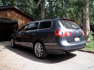
So 6 days after I found it on line, 4 days after I test drove it, one day after mine was taken away, I picked up my new Passat.
Evil front view 
Elegant side view 
Bulbous back view
My new car has all sorts of go-fast features and a 1,000 page manual that will take me years to learn. My old one was a B5 body style; my new one a B7. While I understand the concept of aerodynamics, I liked the B5 design better for practicality. Wagons are shoeboxes on wheels and should look like it.

In a lot of ways, it's good that I had to replace my car now and in this way. The process was painless (a first for me in the car buying world). My old car was becoming worthless, as all cars do. In 3 years, finding a replacement low mileage Passat will be impossible, and all cars get replaced eventually. It is of interest that I paid virtually the same amount in 2004 for a 2 year old car with 14,500 km that I did in 2012 for a better equipped 2 year old car with 16,500 km. There's no inflation there.

Still, I will miss my old car. She was great. I hope my new one is as wonderful. So far it's looking pretty good.

Sunday 17 June 2012

What I learned driving around the USA

We had a fun time on our month long road trip. It seemed like some sort of trip summary was in order.


The Best of the Best Stops:

  1. Custer State Park and the Black Hills. Aside from the excessive patriotism of Mt. Rushmore and the silliness of Crazyhorse, the area is fantastic, and we did not spend enough time there. Great campgrounds, beautiful countryside, great wildlife, fantastic hiking, beautiful vistas, great drives -- it had it all.
  2. Devil's Tower. We REALLY didn't spend enough time here. What a cool spot.
  3. The swamp in South Carolina. Beautiful, quiet, really interesting, neat wildlife, great birds. Absolutely worth the trip. More interesting because our visit wasn't planned; we just stumbled upon the place.
  4. The Smithsonian Air and Space Museums. You don't have to be an airplane buff (though it helps). If it's important in aviation history, they have it.
  5. The Washington and Lincoln Memorials, Arlington Cemetery and the White House. Everything you think they would be and beautiful to boot.
  6. Memphis. Cool city. Beautiful architecture. A little over the top party-wise, but fun anyway. Too much Elvis by several orders of magnitude, but the Gibson factory beckons.
  7. Shenandoah National Park and the Skyline Drive. Spectacular drive, though with "overlook overload". Great hiking opportunities we didn't capitalize on.
  8. Kitty Hawk. An exceptional place to stand on real historic ground.
Never Again Stops:
  1. Kansas City. What a blah town. Terrible aquarium (and it's new, too). Poor farmer's market.
  2. The Blue Ridge Parkway. Skyline Drive is much better. The Blue Ridge has too many annoying motorcycles and puttering North Carolinans, though the southern most 30 miles was nice.
  3. Charleston. The biggest disappointment of the trip. Everything said it was fantastic and we didn't like it at all.
  4. Cape Hattaras. Miles and miles of not much. Windy. Isolated, but still touristy. Bugs. Blowing sand. Crappy camping.
  5. Driving across Alabama, Georgia, Iowa, Kentucky, Indiana, Tennessee. Really uninteresting driving. Several are just hours of driving in a slot through trees. Others are uninteresting farm drives. And note, the drives across South and North Dakota (though long) were at least interesting flatness.
  6. The Badlands of South Dakota. Ours are just so much better.
  7. Several of the Smithsonians, including the Natural History Museum, the American History Museum and the Sculpture Garden. Meh.
  8. The fact that the Air and Space Museums are exclusively catered by McDonalds. Horrid.
  9. Myrtle Beach & Gatlinburg/Pigeon Forge. REALLY glad all we did was drive through, but if there was a way to avoid doing that next time, we would.
  10. Colonial Williamsburg. A theme park disguised as a town. I'd also list Jamestown but there's nothing there to see anyway -- how can you say "don't go" somewhere that isn't there?
Kinda In-between Stops:
  1. The Great Smokies. Overrated. Some nice scenery but overcrowded and overused. Horrible surrounding towns (Gatlinburg was particularly bad).
  2. The Ozarks. It seemed nice, but one or two place we passed though were really unappealing (Osage Beach jumps to mind). Still, I was sick here, so I can't be too judgemental.
  3. Yorktown. Cool battlefield, but still a little over the top "US rules" while ignoring the fact that the French did the heavy lifting.
  4. Little Big Horn. Key learning: General Custer was an idiot. Begs the question why the Americans revere him so much.
Observations on US Park Campgrounds, both National and State:
  1. They are not set up well for tenters, though a surprising number of people still tent. They're set up pretty well for RV's, however.
  2. There's no grey water disposal.
  3. Everyone lights fires, choking you out with smoke every night.
  4. The reservation system tends to be very effective.
  5. There is a high variability in facilities, especially showers. Some we had were great. Others were run down, broken or filthy. Campers tend not to take care of bathrooms, and as such, the counters are wet and a mess, toilets are occasionally unflushed and showers a wet pigsty sometimes.
  6. Most parks have CampHosts (folks camping in the park for the entire summer, helping guests). Some were great. Many were surly.
  7. In our electronic age, there's nowhere to recharge or power your electronics (like, say, camera batteries) except in your car or possibly in the campground bathroom (if you're lucky). I ran into a kid sitting on a bathroom counter playing with his Nintendo while it was plugged in. Said he had been there for an hour. The way it smelled in there, I pity him.
  8. World class bad toilet paper.
Best Eats:
  1. Arthur Bryant's in Kansas City. Without question. We were in and out in 40 min, but THAT'S what BBQ is all about.
  2. 17th St. BBQ in southern Illinois. Awesome food.
  3. Galleria de Paco, Waterloo, Iowa. Fantastic to find great food by accident.
Observation on Driving:
  1. Worst drivers: Minneapolis/St. Paul. They ignore speed limits and blast around at 75 mph in 55 zones, tailgate, don't signal, make triple lane changes. The road system sucked there, too, making it all the worse.
  2. Second worse drivers: North Carolinians. They ignore speed limits, but the opposite way, traveling 30 mph in 45 zones and 40 in 65 zones. They don't signal, don't pull over, don't let cars & trucks doing the speed limit pull out first. When the light goes green, their 0 to 60 time is measured in weeks.
  3. US speed limits are far higher than I expected. Two lane roads in the Ozark Mountains that are never straight for more than 50' and have lots of blind corners and hills have a 65 mph speed limit. Most interstates between cities are 75 mph.
  4. Americans don't speed in the countryside. On the interstate between towns, everyone is within 5 mph of the speed limit. However, they do speed in the cities. The second you get close to a city, speed limits tend to drop (from 75 to 70 to 65 to 60 to even 55) but no one slows down.
  5. Canadians, on the other hand, speed in both spots. They start hurtling the second you cross the border into Saskatchewan, and all the way though Alberta from the US border to the BC border to the Saskatchewan border.
  6. The American interstate system is in much better shape that I thought it would be. Americans always talk about their "crumbling infrastructure" but I didn't see much of it. Its worst in cities but not bad really anywhere.
  7. Americans signpost road construction far in advance. We saw signs that started with "Road Under Construction 42 miles ahead" and they counted down with new signs every 5 miles. The construction was inconsequential.
  8. By contrast, Canadians don't warn about construction at all. Suddenly the left lane will be closed by barriers without any warning at all.
Other Random Observations:
  1. There are more churches than people in South Carolina. There's a reason it's called the bible belt.
  2. Rain from hurricanes and tropical storms is unlike other kinds of rain, even from thunderstorms. Imagine someone standing above you throwing buckets of water on you.
  3. I'm not a huge fan of The Weather Network in Canada, but The Weather Channel in the US is worse. At least the Canadians give you the weather. Tune into TWC late at night and they're playing TV shows like "Ice Road Trucker". They spend all their time talking to their very own StormChasers for hours on end without breaking for local weather. When they do give the local weather, it's only the weather for the 30 miles surrounding the station you're watching. Heaven help you if you drive more than 30 miles, because they're not going to tell you the weather.
  4. The National Weather Service's website is not friendly, and neither is WeatherUnderground. Environment Canada makes it easy to get forecasts. To get one in the US, you need a zip code. The icons are silly and meaningless. Their technical displays of radar and satellite are confusing and not helpful.
  5. If you want to drive in the USA, get a GPS, but get a good map too, because our GPS was wrong at least a few times a day. "Wrong" as in being on a road that wasn't mapped, being told to go one way when the road signs clearly showed to go another, being told it would take 4 hrs to get somewhere when it only took 2, etc.
We like road trips. Will we do them again? Sure. But we will do fewer cities and more wilderness, pay more attention to reviews of campgrounds and their facilities, source power for our electronics better and probably spend longer in each place we visit.

And we'll try to avoid hailstorms, unless I need a new car. 

The MD Weighs In on our Reno

Before we left on vacation, we hired a contractor to do our upcoming reno and tasked him to obtain the needed permits from the local Municipal District (MD, our government) while we were gone. Only a few days into the trip, we found out that the MD needed a written letter from us authorizing the contractor to do things on our behalf. It happened to be in Mitchell, South Dakota (where my car got destroyed by a hailstorm) that we pulled together a letter, printed it, signed it and faxed it to the MD. I was faxing the letter when the hailstorm hit.


We arrived home to find that one of the two needed permits, the Development Permit ("DP") had been issued. The Building Permit is still under review.


The DP had two conditions in it. Now, before I explain the conditions, be aware our reno achieves the following:

  • Adds a 7' extension to our kitchen, including a basement room underneath it;
  • Moves the sink 4', and turns the dishwasher 180°;
  • Moves our washer/dryer upstairs. Currently they sit in the basement, below the level of the septic tank. When the washer empties, it has to pump up, and when the pumping is done, about 4 liters of wash water drains back into the machine.
  • Replaces our roof, and stops it leaking;
  • Fixes the drainage on the house and stops the basement leaking;
  • Repairs the failing retaining wall in the back yard, making the property safer.
The MD put two conditions of interest on the DP approval:
  1. To make sure the driveway is inspected and confirmed that it is in the correct place, and
  2. To insure that our septic tank is performing in accordance with the current (2009) standards for private septic systems.
The driveway? We're not changing the driveway. The driveway has been there for ~40 years. Why check it now? Our contractor had the MD's inspector come by and they said it's fine. But why even bother to put that condition on? In addition, the driveway has to comply with an MD policy (Policy T-16) that you can't get off the MD's website. You have to get the MD's inspector to give you a copy. So you have to comply with a rule, but they're not going to tell you what it is...

Our septic system (two tanks and a field) was installed around 1973. In the mid 1980's, the house was expanded and 2 bathrooms were installed. Nothing has been done since. But because we want to move the sink 4', we have to confirm the septic system is in compliance with the current (2009) code -- not, I hasten to add, the code in place when the system was installed. We have to incur additional expense to make sure the system that has been in place since the early 1980’s would meet a design standard of 2009 to do the same job it’s been doing since the 1980’s.

So we called a local engineering company (an engineering stamp is required by the MD) and they came to look. We have no information on the location of the field, and the only thing we know about the septic tanks is (a) what we can see, and (b) the info on a private septic inspection we had done as a condition of purchase.

The engineer came out and poked around in our yard for an hour or so with a long rod trying to locate the field to no avail. Our ground is rocky, gravelly glacial till, and he either ran into rocks 6" down, or the rod went in 6' without resistance. We haven't yet had a formal proposal for a work plan, but right now, here's what he thinks we have to do to move our sink 4':
  • Dig around the septic tank outlet to find the pipe leaving the tank
  • Inspect that pipe, look at the soil and search for bacterial evidence of treatment;
  • Dig at least 10 holes ~3' deep in the yard to locate the field, including the header and the laterals;
  • Inspect the exposed pipes, and the soil, and look for bacterial films;
  • Establish the actual size and location of the entire septic field.
All to move the sink 4'.

Why? Good question. Probably because the MD doesn't like the use of septic systems in our community. They spent millions a few years back to convert the commercial businesses in the hamlet onto a sewer line. But because of the cost involved, no residents joined the line, and there's no infrastructure connecting the residences to the line. If the MD manages to "force" people on to the sewer line, they can increase the density of the hamlet, and sell off the municipal reserve (forest) lots in the hamlet - like the 5 acre forest across from my house. No one in the hamlet wants them to do that. So conditions like this are the MD's way of trying to force us onto their sewer line -- for which we would pay ~$100,000 over 30 years, plus the cost of sewage treatment.

All the move the sink 4'.

And in the meantime, the work held up means my roof leaks, my basement leaks and my retaining wall continues to fail. But only when it rains -- like, say, last weekend when we had record rainfall and there was flooding in Canmore.

Dealing with the MD is SO much fun.

Home and late

We may have arrived back from our trip 2 weeks ago, but it has been a very hectic 2 weeks as we strive to get our life back in order. Many, many posts are to come on the events, including:

  • My car. The insurance company wrote it off, so I had to buy something new;
  • Montreal and the Formula 1 race. Year 8 (I think) of my attending the race. It rained this year, too, but not on race day.
  • Our reno project. The Municipal District put some conditions on our approval, and we've been working to clear those.
  • Too many airplanes. I spent 10 hours in the two Smithsonian Museums, and will post a "best of the best" of what I saw, including a photo of a plane from which I am only one degree of separation.
  • Working on the trails. I spent a day volunteering to repair and close some trails, plus put in area closure warning signs. My knees got into the local paper.
So here we go. Stay tuned!

Friday 1 June 2012

More food finds

I'll tell you, driving from North Carolina to North Dakota has been like doing the 3 hour commute between Calgary & Edmonton 3 times a day for 3 days. Flat and boring. Fortunately, the food along the way has at least been interesting.


Just outside of St. Louis we stopped at a chain BBQ place called Bandana's. For a 31 store chain BBQ, it was pretty good. The brisket was a little dry, and the pulled pork tasty but a little bland. I was mentioning about sauce choices in an earlier BBQ post; these guys take the cake, with six: a home made mustard style, a Kansas City style, a "Chicago" style (there is no such thing), a "St. Louis" sweet & smoky style, a "Carolina Smokin's Hot" style (Carolina BBQ is not smokin' hot) and a Memphis style. None of these are even marginally real or close to what you get in Memphis or Kansas City et. al., but I tried them all and they all tasted different and good anyway. The home-made sauce added a Carolina mustard-like flavour to the pork and made it much better. The St. Louis style was very smoky (heavy on the hickory), and overpowered the brisket (which was cooked very Texas style). The slaw was good if a bit runny, and the deep fried okra was surprisingly good. Overall 3.5 stars out of 5.


We had one heck of a surprise in Waterloo, Iowa (which is one of the many places we have come to refer to as MOFN -- Middle of F#%@ing Nowhere. All states have them). We found a restaurant called Galleria de Paco that is notable on 2 counts: First, the food was awesome, and it was served European Style with a 4 course fixed price menu for only $27.99. This was an absolutely excellent deal. Very creative chef, lots of cool things to choose from.


But second, it turns out the chef is also a 23 year old graffiti artist who escaped from Bosnia with his family while the war was on. He works exclusively in spray paint. He took 4 months (and 9,000 cans of Krylon paint) and did an amazing reproduction of the ceiling of the Sistine Chapel in the Vatican on the ceiling of his restaurant. You gotta look at this YouTube video to believe it:
Did I mention that the gentleman is self taught, both as an artist and as a Chef?


It's treasures like this that make road trips worthwhile.


We're currently in Fargo, North Dakota, a 2 day drive from home. We have made it this far without thunderstorm incident, and we should get to Moose Jaw tomorrow.


BTW, I promise the airplane pictures are coming.