Sunday 22 August 2010

Hunt-ing down the Burgess Shales (and Pikas)

A while ago, some friends of mine set up an online auction to raise money for someone who was fighting cancer. In the auction, I bought a guided hike for 12 to the Burgess Shales. While I had been high above Emerald Lake on the Wapta Highline Trail before, I had never been to the quarry. Given it's significance (it's a UNESCO World Heritage site), access is only allowed in guided tours.

It was easy to find 10 folks to join KC and me. My company is full of field geologists who like fossils and who also happen to be avid hikers who are up for an 875 m climb and a 22 km hike.

We generally lucked out with weather. Calgary has been a pit of forest fire smoke for a week with no viz and the acrid smell of a campfire. But Saturday in Yoho was blue sky and cool. The hike starts at Takakkaw Falls which, at 384 m, is Canada's second tallest waterfall.


Takakkaw is glacier fed, meaning that by the end of the day it had a lot more water in it than in the morning. Here's a shot from the exact same spot taken at 5:30 PM.


The hike switchbacks up about 280 m, then gently climbs through a dense forest to Yoho Lake, site of a backcountry campground.


The trail leaves the campsite and plasters itself against the face and scree slopes of Mt. Wapta...


...as it climbs up to the shale beds. This results in some very cool views, first of No See Um Falls and the Emerald Glacier...


...then of Emerald Lake itself.


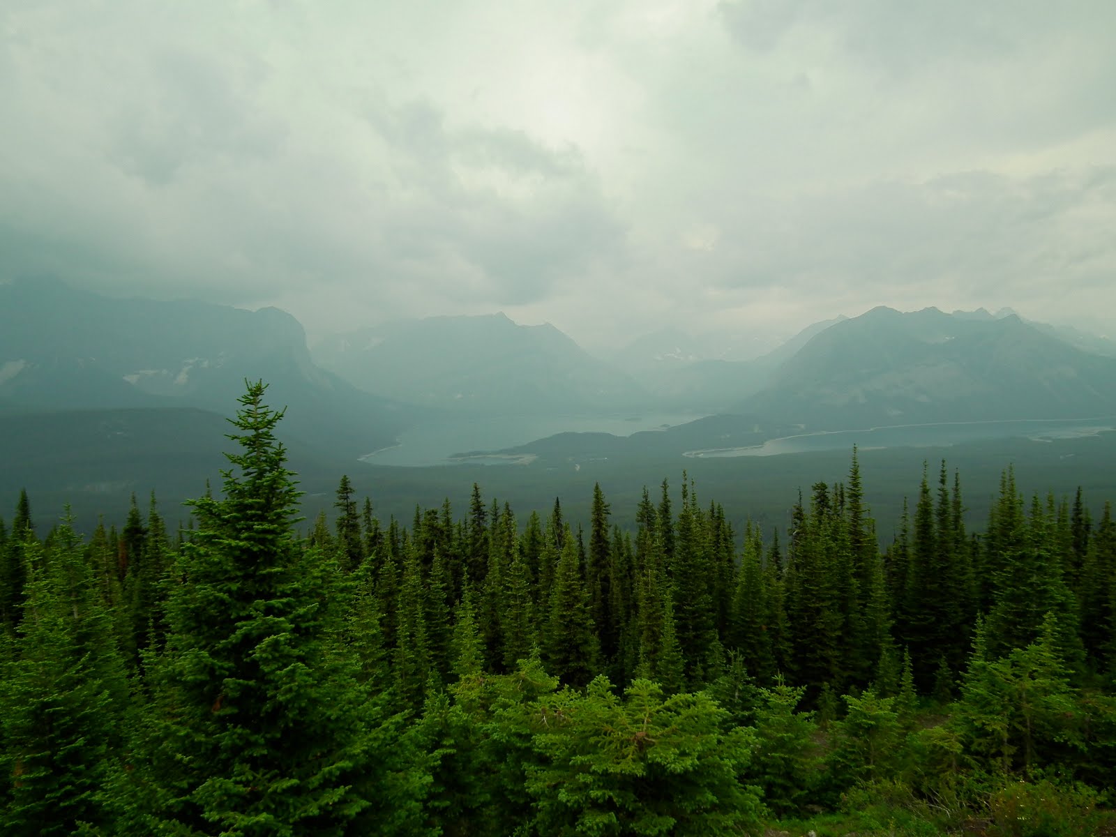
The formal trail skirts the edge of the fossil bed. A separate trail climbs up the last 130 vertical meters to the quarry itself. This trail offers views over Burgess Pass to the Trans Canada Highway.


Eventually, you get up to the discovery site and the Wolcott Quarry. I was truly surprised at how small the quarry is. Despite the fact that over 300,000 fossils have been taken from the site, it's only about 100' across and cut 30' deep into the hillside. "Unassuming" would be an understatement. The sample fossils they keep there to show are astounding.


Our guide said the fossils were "everywhere, everywhere". I personally found only 2, and in some ways, I'm not sure they were actual fossils.


After some 5 hrs hiking up (with another 2+hrs down) you get all of 45 min in the quarry. Ah well.

It started to sock in as we headed down, and rainclouds were swirling up high.


Rain started in earnest for the last 150 m of switchbacks down to the parking lot -- 150 greasy, slippery metres. But it was just a shower and didn't last long.

It was an interesting animal day. I saw a snowshoe hare and a deer on the trail, but both took off and I could get no photos. I saw the typical ground squirrels. But at lunch we sat about 10' from the midden of a Pika who made 4 or 5 trips in to fill it up, at one point transiting under the rocks I was standing on. He was very cute but was clearly not in a mood to stay too still.


I want to thank my fellow Hunt employees who participated in this hike and in doing so, helped support a family hit by cancer.

Saturday 14 August 2010

Smokin' Again

Good morning. As I type this, it is just before 2 AM and I am working on my annual smokefest.

A number of years ago, one of my employees planned an employee recognition & team building event, and hauled some 40 people into a master barbeque class taught by Ron Shewchuk. Never heard of Ron? Maybe you have heard of Rockin' Ronnie & The Butt Shredders, his award winning BBQ team. Rockin' Ronnie is the author of several books, including Barbecue Secrets. Our day long class taught us how to smoke brisket, ribs, chicken and pork. It was a blast, and the food was great. The only problem is that it's kind of a time consuming pain, so can only be justified if you are cooking for a large group.

My current company hosts and annual BBQ for employees, and my boss and host had historically cooked up some brisket for the party. The first BBQ I came to, I volunteered to cook the brisket. Last year, I surprised everyone by cooking both brisket and pulled pork. And this year, I'm at it again, with the Q just chock full of protein. In fact, there's a little competition going, as someone else is also smokin' some butts. This is perfect: 45 folks and one heck of a lot of barbecue.

I do a low and slow overnight cook. Tonight, I lit the Q at 10:15, and the briskets went on at 10:30 PM. These are the biggest ones I have ever cooked, at 11 lbs and 10 lbs each. At this moment, I'm just about to prep the pork, which I'm planning on putting on at 4 AM. Here's how it comes from my local CoOp, with two bone-in butts in a cryovac pack.


I cook in my boss's Webber Smokey Mountain Cooker out on my back deck.


This device amazes me. I put in about 15 lbs of charcoal and light it, and once I have balanced the lower vents, the thing will hold a 225° cooking temp for literally 18 hrs. If it wasn't for me having to open it to (1) add the pork, (2) turn and baste a few times, I could probably go to bed right now and take perfectly cooked brisket and pork off it tomorrow afternoon at 4:30 PM.

That is not to say this is effortless and that anyone can do it first time every time. Year one the temp on the brisket stalled (stopped rising) some 30° short of target at 8 AM and hadn't budged by 3 PM, so I had to do some quick work to finish it. Last year, it poured rain for a few hours overnight, and I sat up babysitting it until 5 AM, worried the Q would lose temp (it didn't).

This year, I have added something to the mix by whipping up my own dipping sauce. I love brisket, but I remember from my days in Texas that it was always served with sauce of some kind. My last few briskets have been fantabulous but a bit dry. So the dipping sauce, which rocks with pork too, should be great. This year, I also picked up a remote reading thermometer (it's that wire leading out of the Q in the photo). I set the Q up so I can see the Q's temp from the kitchen window, and I do have a probe thermometer, but I have trouble reading it from inside. So my new remote reading device allows me to know the temp of the brisket anywhere inside the house. I'm planning on using the old probe one for the pork butts.

If you have never had real smoked pork or brisket, you gotta try it. In Calgary, I hit Palomino Smokehouse every month for a pulled pork sandwich. Big T's is also pretty good, across from McMahon Stadium on Crowchild. Folks, THIS is food.

Sunday 8 August 2010

3,440' up Cory Pass

Likely the most popular serious hike near Banff townsite is the Cory Pass/Edith Pass loop. It isn't Ha Ling steep (Ha Ling rises 810 m in 2.8 km; Cory Pass is 975 m in 4.8 km), but at times it feels like it.

The weather wasn't great all day, mostly overcast, and in the morning some low lying fog filled the Bow Valley. The first 90 min of the hike climbs 525 m up a grassy ridge with ever improving views of the Vermillion Lakes and the valley.


You gain a rocky knob with the first actual views of the pass -- the V notch on the left side of the photo below, still over 2 km and 400 vertical metres in the distance.


The trail is slightly visible in the photo, angling to the pass across the scree slopes below Mt. Edith

Along the ridge there's a spot of downclimbing on this steep rock face. While not hard, it pays to be very careful and be thankful for some of the trees that make good handholds.


When I say the trail hugs the scree slopes, I mean it.


While the valley leading up to the pass is sure pretty, the pass itself isn't much more than a gap in the rocks. It offers OK views back along the trail route...


...but it is full of neat rock formations that give the Gargoyle Valley on the far side its name.


The whole area up here looks like perfect goat habitat, but we sadly saw none. It's also supposed to be windy up here all the time, but it was dead calm for us.

Crossing the pass drops you into Gargoyle Valley. The trail flanks the scree again all the way to the head of the valley in the gap between Mt. Louis of the left and Mt. Edith on the right.


Now to me this is dumb trail building. I would have built switchbacks descending to the valley floor then headed the trail out on the flats.

The mouth of the valley is full of big rocks and the trail kinda disappears, though there must be 20 cairns scattered around marking a handful of routes. This looked like good Pika country but again we saw (and heard) none. The other side of the rocks suddenly becomes green into the backside of Mt. Brewster and the valley of 40 Mile Creek.


To the pass, you have climbed 975 m, and it's been downhill from the pass to this spot. Now you get to climb again, and while it's not much, on the order of 75 m, it's steep and sure unwelcome. Especially so since the trail is vague and cruddy.


Looking carefully at the photo, there's actually a small orange sign in the trees in the centre of the frame, and that's where the trail heads. And yes, that's a mosquito parked on the lens. They were out today, but not in the forces they were last week.

Once you hit the trees, the long 5.5 km descent starts, and aside from the odd avi slope with views of the backside of Mt. Norquay & Mt. Brewster, and the classic view back to Mt. Louis...


... it's a disenchanted forest walk in a creek valley, with the only bright side being that the moss covered ground is quite pretty and very soft.


Fortunately, we had a very nice distraction for this section of the trail. All day long we kept running into a very nice pair of young lady tourists from Paris and Germany. They had actually arrived at the trailhead by taxi (only in Banff) and we offered to drive them back to Banff at the end of the day. We intercepted them at the creekbed and got to chat with them all the way back.

This trail is not for the feint of heart. It's tough, and a strenuous workout. It raises my respect for the folks who climb Mt. Edith, who slog up the trail in the dark hauling climbing gear, and once at the top, then actually climb the vertical rock faces. We saw numerous pitons and climb starts while on the hike. Personally, I would be dead tired and climbing the mountain would be out of the question.

Monday 2 August 2010

Not much to see from the Lookout

Another overcast day threatening rain caused us to be boring, stay fairly low and head to the Kananaskis Fire Lookout. This is a fair haul from the West Wing, but had the right combination of vertical gain, distance and low top altitude for a blah day like today.

We opted to access it from the Hwy 40 start. The Pocaterra ski trail is a boring fire road (the whole hike is a boring fire road), with the only real interest being the scads of bear poop and the other elk, moose and deer tracks. The lookout itself is bigger than most I have seen...


and the lookout folks working there were happy to have us visit. There was even bug goop in the mailbox that had the visitor register (and the mosquitos were just as bad as yesterday). The view wasn't breathtaking because of the cruddy viz, low cloud, patches of rain and smoke from the various fires burning.


They have a resident ground squirrel who has to be the fattest beast I have ever seen.


Maybe he eats the pie plate sized mushrooms.


The only other real attraction for this hike was the wildflowers, and they are indeed in season.


Next time, I would bike the section to the Tyrwhitt intersection, which is about half the distance with none of the height gain.

Sunday 1 August 2010

Finding the Secret Cave

I was surfing the web a few months ago for info on Lac Des Arcs, and ran across this article regarding a cave under Mt. McGillivray. I found the article intriguing, as having read pretty much every hiking book about the area cover to cover, no one had mentioned it.

Today was not a great day to get too adventurous in the neighborhood, being overcast with rain threatening. So we opted to find the cave. Turns out it's not that secret.

The trail to the cave isn't in Gillean Daffern's book (at least not in the current 3rd edition. Maybe it will make the 4th, which is due out soon). In fact, the Trans Canada Trail from Heart Creek to Dead Man's Flat's isn't in the 3rd edition either. But either way, it's a hard trail to miss. Take the Trans Canada Trail west out of the Heart Creek parking lot. The TC trail is obvious; aside from a few diversions around creekbeds or the powerline, it's a single lane road. After about 2km and 20 minutes, you get to a 4 way road intersection. Head left (or straight; the left turn just cuts off a switchback). Climb up about 50 vertical meters in 2 big switchbacks to the cliff face. Until this point there's no views; at the first switchback you can start to see back over Lac Des Arcs...


Then within 100 m you get to the cave entrance. Total climb from the parking lot is 100 m.


Like all caves, it's dark inside, especially so when your eyes are accustomed to the bright light outside.


The tunnel goes straight back about 50 m. About 20 m in, there's a passage to the left with two large rooms, each 20 m by 30 m. It's cool inside, and it was dripping wet. Like all caves, it's basically at 100% humidity, but wasn't warm, being only about 15°.

What bugged me is that the cave stinks of campfires. There is not one part of the tunnel that does not have a campfire ring within 5 m of it. I counted at least 10 rings or ash piles. In the ceiling are some remaining reinforcement metal rods, and one sticks out from the ceiling about 2 meters. On the end of it is a dead glow stick, held on with electrical tape, directly above a campfire ring. There are broken beer bottles in most every nook and cranny. Tragic, that.

It's pitch black in the left turn passage; we had two flashlights, and it was just barely enough to see. The floor is flat but rocky and there are lots of campfire rings to avoid tripping over. Graffiti goons have, of course, splashed a tag or two here and there there. It's also quiet; there's traffic noise the whole trail, but in the cave, there's just the sound of dripping water.

Folks were climbing the McGillivray Slabs just the the right of the cave...


...and an osprey was soaring above us when we came out.


The weather remained threatening, and in fact a thunderstorm came out of Exshaw Creek and got us just as we were getting back to the car.


However, on our way back, we ran into a huge patch of wild raspberries. We stopped for about 10 minutes and picked about a half a waterbottle full (losing the lid in the process. If you find it, send me a note...). Yes, every red spot in the first photo are raspberries. We did not pick them all; we know this spot is popular with bears, and we like the bears to eat, too.


The cave is worth finding. However, I don't think it's worth camping in.