Sunday, 29 May 2011

White and gold

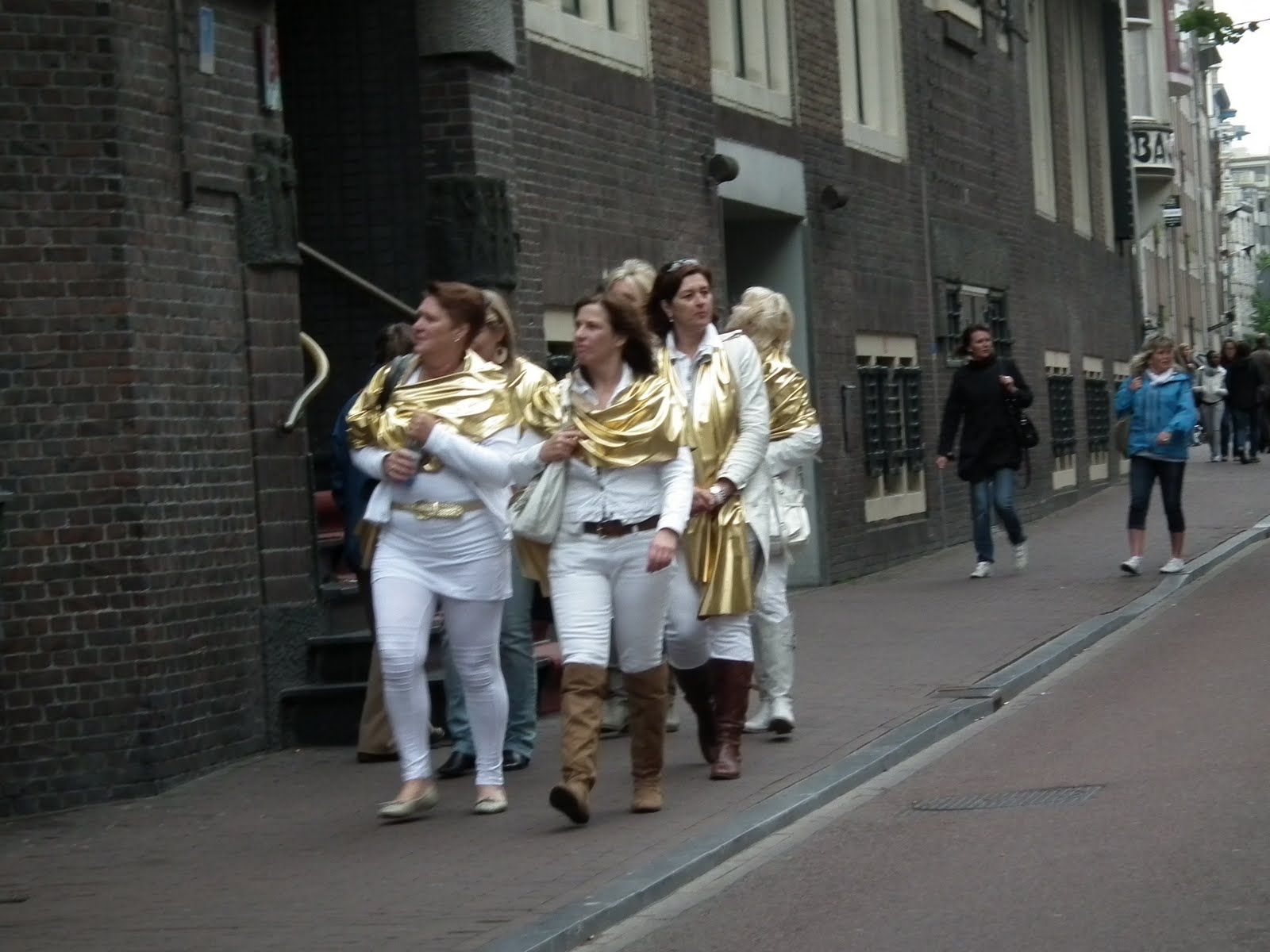
For some reason, there were a lot of people (mostly women) wandering around Amsterdam this weekend wearing all white with gold accents. And they were generally not kids, but 35-50 year olds, and they were everywhere. We even saw some on the train back from Den Haag today. Here are a few examples, and these photos were taken over the space of 3 days:
Gold lamé pants?
He had gold chains. She had a gold sequined waistbelt
Three gold lamé hats. Two gold sashes
Braving the cold, but no lamé
Gold lamé scarves and tiaras
Any guesses? Or have gold lamé pants come back into style, and I just missed the memo?

What do things cost in markets?

I like shopping in the street markets. I'm not a fan of haggling, but I like the markets themselves. People have been asking me, "What do things cost in markets?" Perhaps this will help.
All the prices in one place for your convenience

Friday, 27 May 2011

Being a pedestrian in Amsterdam

There's remarkably little traffic in downtown Amsterdam, but this does not make this city pedestrian friendly. In fact, quite the opposite.


There's a clear pecking order here that took me a while to figure out. It goes like this:

  1. Trams. They bite. They actually stop for pedestrians in marked crosswalks, but only if they have time and are on schedule. Otherwise, they are hurtling masses of steel.
  2. Busses: There's not a lot of them, thank goodness. They stop for no one. They are wider than the trams and push bikes and cars out of the way.
  3. The Dutch on scooters. Scooters are strangely allowed to use all the bike lanes, plus the roads if they feel like it.
  4. The Dutch on bicycles. More on this in a moment.
  5. The Dutch on foot. They storm along warily watching for oncoming trams, busses, and bikes, in that order. They do not change pace or path for anyone. Cars are something to be walked around, whether moving or stationary.
  6. Tourists on bicycles. Always on well marked rental bikes, so they're easy to spot. Ride on the defensive, which they are, because even the Dutch pedestrians will walk right through them.
  7. Tourists on foot. Almost the lowest of the low. Moving targets for the Dutch on their bikes.
  8. The Dutch in their cars. They give the Dutch on bikes a wide berth. And they almost always stop for pedestrians.
This town is almost owned by the Dutch on their notorious "Amsterdam City Bikes", beat up black things that usually squeak and often have flat tires. The Dutch on bikes do not stop for anything they don't have to, nor do they slow for anything. There are no speed limits. A light ring of their bell means "you're about to die because you're in my way." It's far more dangerous for a pedestrian to enter a bike lane without looking than a road, even if there are cars coming. As noted, cars will actually slow and stop for pedestrians.

There are no sidewalks here, per se. Sidewalks have been turned into one of a few things: bike lanes, in which you really shouldn't walk; bike parking lots, in which you can't walk because there are so many bike parked; or outdoor cafes. There are, in fact, a lot of pedestrians, but there's just no sidewalk left for them. It's not just like this in Amsterdam; out in Alkmar, Leiden, Nijmegen and elsewhere, things that look like they were once sidewalks are now designated bike lanes.
Bikes occupying the sidewalk while the bike lane is clear
The clear pedestrian path
Dutch cyclists control the speed of traffic in many places in the city. They ride up and down streets like ours without bike lanes as if they own the place (which they do). Since the streets are narrow, the cars can't pass.
Bicycles owning the road
Dutch cyclists don't wear helmets, and they rarely signal. They pay attention to traffic signals when it involves trams or busses but otherwise do what they want. They have their own crosswalk light buttons and they occasionally use them (if it involves crossing tram tracks).

There can be as many as 5 walk/don't walk lights for pedestrians to cross a 2 lane road, and they are not synchronized. There's one for the first bike lane, one for the first lane of traffic, one for the tram tracks, one for the second lane of traffic and one for the second bike lane. And remember that the bike lanes are only about 4' wide.

A normal day like today saw us have a half dozen close encounters with death by bikes. They're whizzing through stop lights, or in places where the sidewalk was totally blocked by bikes (or construction, or the tables of a cafe, or a store's merchandise, or a display, or flower pots, or any of the other of the myriad of things that people put in the way of pedestrians) and entering the bike lane was necessary. One construction site was such a mess they laid down mats to cover the sand, mats not wide enough for 2 people if one was pushing a bike. Of course, the bike pushers (who are Dutch bike riders who can't ride) have the right of way, and everyone else has to get off the mat for them.

Scooters are bike riders on steroids. Not only do they not yield the right of way to anyone, they will ride on the sidewalks if they feel like it. 50 km/hr on a bike path? Sure. They have horns. Thank goodness it's not Italy and there aren't a lot of them.

Dutch pedestrians are just cyclists without their bikes. They say there's 600,000 people and 700,000 bikes in Amsterdam. It follows logically that every Dutch pedestrian here is simply walking to get their bike. So they walk like they bike, with total disregard for anything else -- except the bikes they know will hit them.

I thought Amsterdam would be a pedestrian friendly city. I felt safer as a pedestrian in Rome. At least there it was obvious I was a target. Here they're sneaky about it.

From time to time, I will come back and add some photos to this post to show you what the sidewalks and bike lanes look like -- if I am brave enough to stand in a bike lane to do it. So check it from time to time over the next few days.

Touring the Ypres Salient by bike

Before heading to Belgium in May 2011, I searched the web high and low for advice on how to tour the Ypres Salient area on a bicycle, and found very little information. So I write this for the folks who may be searching for the same info.


Can you tour the war sites in Ypres Salient by bike?


Absolutely, so long as you do some advanced planning. Planning on the fly is not that hard but with thoughtful advanced prep your time will be better spent. There are designated bike routes (I call them "fietsroutes") thought the Salient, though they are generally designed to ride from Point A to Point B, and not to hit the sights. Many (not all) roads have bike lanes, but there are a few roads you can't ride on. Some sights have bike parking. The land is generally flat, and the hills that are there are inconsequential (unless you were a soldier in 1914-1918). Distances between sights is fairly short. A 40-50 km ride will accomplish a lot.


The only thing to worry about is the wind, which generally blows west to east. Since the land is flat without many trees, there's nothing to stop it.


How do the Fietsroutes work?


Little green signs direct you to numbered intersections. For instance, the Ypres Train Station is intersection 30, the Menin Gate is 33. The numbers are NOT related to sights to see, but to places where path intersections occur. The maps show distances between the numbers, so you know exactly how far you are riding. In the field, you simply follow the directional arrows to the next number. It really is hard to get lost.


Where can I get a bike?


You can only rent bikes from two places in town, the Hotel Ambrosia or the Campground. The railway station did rent bikes, but they are not doing so as I write this in May 2011. The Ambrosia bikes are 6 speed, in very nice shape, easy to ride, readily adjusted and cost just €10 per day. A credit card number is left for a deposit. Wreck the bike and it's €350. You can call ahead and make reservations for a bike.


The campground is a little out of the way, halfway between the Menin Gate and the Lille Gate outside the moat, making it less desirable a rental spot for people staying in town.


What do I need to plan my trip?
  1. Knowing what you want to see. You can't see everything. There's 187 cemeteries alone. If you want to see the sites primarily devoted to the Canadians, or to the Austrailians, or a specific regiment or battle, plus add the famous sites or a museum or two, you can. But to see everything in the Salient would take months. To help you narrow it down, you need:
  2. The book "Major & Mrs Holt's Battlefield Guide - Ypres Salient and Passchendaele". I looked briefly at their Pocket guide and can't really recommend it as it omits too many important sites. From the full detailed guide, you can easily pick out the highlights you want to see. You will probably want to see more than you can (as we did). All I can suggest is either stay longer or prioritize.
  3. The best overall bike map for the area is the Westhoek Zuid Fietsnetwerk map published by Tourism Westhoek. This €6 plastic map (ideal for all weather use, and tough to wreck) covers the area around Ypres and basically all of the Salient. While it shows very few historic sites, at 1:50,000 it's detailed enough to get around on, and also to plan your own routes. It shows all the off-road and designated bikeways. It does NOT show the roads with bike lanes. I suggest getting one before you leave home, but you can buy them in the VVV office/In Flanders Fields Museum gift shop on the Grote Markt in central Ypres. The Ambrosia even has some for sale.
  4. The best map to identify the location of the sights is "Major and Mrs Holts Battle Map of the Ypres Salient". This map shows all of the sights and has a detailed road map, but none of the bike routes. These days, the map comes with the Battlefield Guide. The nice part about this map is that it shows every country road (but not the off-road bike routes, nor the roads inside the towns).
With this set of tools, use the Battlefield Guide to pick your stops Use the Battle Map to locate them, and mark them on the Fietsnetwerk map. From there it's easy to design your own routing, carrying only the indestructible Fietsnetwerk map and the Battlefield Guide with you.


The Battle Map is not plastic and barely weathers a day spent flapping in the wind before tearing at the folds, so don't carry it unless you have to. The Battle Map without the Battlefield Guide gives you no understanding of the sights, it merely lists them all. But you can't find the sights in the Battlefield Guide without the Battle Map, as the directions given follow a driving route that bikes generally can't follow. So you need all three.

That sound like work. Is there an easier way?

There are a few marked loops out of Ypres selected by and planned by Tourism Westhoek. One, the Peace Route, is about 40 km long. These routes have their own guide maps (and signposts along the way) and you can get them in the VVV office/In Flanders Field Museum gift shop. However, if you are interested in particular things, I guarantee that you will miss them if you follow these pre-planned routes.


At this time, I'm not aware of guides who offer guided bike tours. There are lots who will drive you around in their van. The funny part is the sites are sometimes so close together that the bikes beat the vans going from place to place.


I don't have a lot of time. What's close to town?


Essex Farm, where John McCrae wrote "In Flanders Fields", is a 40 min walk/15 min ride from town. The fietsroute would be 30-33-34-35-24 (stopping before you get to 24).


A very short loop south of town on the Fietsroutes will take you to Hill 62 and the Hooge Crater where you can see museums, monuments, important cemeteries, trenches, craters and shell holes, and would take a half a day at most. The fietsroute would be 30-36-48-47-44-42-55-56-32-33.


In fact, if you just rode out of town under the Menin Gate on the bike path on Menin Road, in about 15 minutes you will come to the Hooge Crater/Hill 62/Sanctuary Wood area. Just be aware this road (which has an on-road bike lane) is very busy.


What's it like to visit there?


Moving. See my post here.


Enjoy your trip. Ypres is a pretty little town, and the Belgian countryside is a great place to visit. Note that it is farm country, and sometimes smells like it.

Thursday, 26 May 2011

Honouring 300,000 lost souls

We got back yesterday from a 3 day trip to Ypres, Belgium, site of numerous World War 1 battles that were fought by many Canadian soldiers (among a whole lot of others, including Australians, New Zealanders, British, Indian, French, Belgians and others, but being Canadian, my focus was the Canadian involvement). You cannot help but be struck while traveling in the area of the enormity of the hell that occurred there.


We were based in Ypres, a pretty little town that takes no more than 15 min to walk across, has been here since it was founded about 1,000 AD, and that WW1 flattened. Eradicated. Laid to waste. There's no building in this town that was standing after the war. Everything was rebuilt, and in the case of the main buildings, from the original plans. Like the great Cloth Hall, which was the home of the silk and fabric trade that this city was known for for about 1,000 years.
Cloth Hall and the Grote Markt main square
The hall is now home to the main (of many) museums in the area, the "In Flanders Fields" museum. The church, built in the 1200's, was blown to bits but rebuilt, too. The top half of the tower was always planned but never built until the 1920's. The church steeple makes for an outstanding landmark as your tour the area, because being basically as flat as a pancake, you can see the centre of town from the entire battlefield.
The outside, complete with flying buttresses
The rather gargantuan interior
The town was originally built in classic fashion and is surrounded by a moat with rampart fortifications. While the tops were shelled to bits, the walls were mostly untouched by the war.
50' tall walls with access for protected boats
One of the entry gates
Now a road tunnel
Starting from scratch means you get to build new stuff, and I thought these cantilevered sunrooms on this apartment building were creative.
Gives new meaning to the term "hanging out"
The city sits on one of the many main canals in the area, now underutilized, but for hundreds of years a main thoroughfare with access to the port of Dunkirk.
The Ypres-Ijzer Canal
The town would be a peaceful little place to visit were it not for what happened here. In order to understand that, permit me one paragraph of history.


In 1914, using the Von Schlieffen plan, the Germans planned to invade France by running an end-run around the fixed French Maginot line defenses through Belgium. The Belgians didn't like this and slowed them down. The British and the French arrived in time to stop the Germans moving forward, and did so in a semi-circular arc of 5-10 km radius around the town of Ypres. And there, for 4 solid years, neither side could gain enough advantage to move the line despite 4 main multiple-month battles. They (and when I say "they", I'm talking both sides) dug into to trenches. The blew up a LOT of mines, especially under the trenches. They (the Germans first, then the British and French) tried mustard gas, phosgene gas and chlorine gas. They tried flame throwers for the first time ever. They tried tanks for the first time ever. They put down so much artillery that on average, one shell exploded every square meter of ground. They turned the place into a swampy wasteland devoid of trees and full of rats. And with all this work, the line moved back and forth just 5 km between the towns of Ypres and Passchendale several times between 1914 and 1918. This four years resulted in over 300,000 Allied forces killed including over 90,000 missing, and total casualties in both sides broke 1,000,000.


We started our tour about 5 km north of town where the bulge that starts the semicircle begins. Here, Yorkshire Trench was unearthed in 1992 when they wanted to turn the land into an industrial park. It not only features a trench, but (now flooded) access to one of the many underground bunker/command posts that were used by the British, plus the added bonus of seeing what three years of war achieved here.
1917 on right. 1914 trench under the boardwalk
From inside the trench
The old and the new; down into the bunker
From here, we went to Kitchener Wood (yes, there are a lot of places here that in WW1 were named after parts of Canada). The first use of gas in the war was in 1915 by the Germans as the first assault of the 2nd Battle of Ypres, and the cloud came as far as here where there was once a forest, wiping out and incapacitating a French and Algerian division. The attack was launched from about 3 km away (just past the red buildings in the photo below if you enlarge it). In those days of the war, 3 km was a HUGE advance, and the Germans were poised for a breakthrough. But they were stopped by the Canadian forces, who were gassed again two days later. The Canadians did not budge despite terrible losses and no gas masks. The line stopped moving again here, ending the German offensive.
The gas cloud shaped memorial
There are bunkers all over the place. While the Allied forces build underground installations, the Germans built above ground bunkers out of pre-fab concrete, and when the lines were stalemated, these strongpoints propped up. This one not only survived WW1 and WW2, it's now part of the guy's barn.
Bunker at Cheddar Villa
This one was once a German HQ
Now halfway to Passchendale, we ran across our first main Canadian memorial.
35' tall
The Brooding Soldier
Why it's here
Somewhat stirring
Just down the road is the Tyne Cot cemetery. It's really hard to grasp the enormity of this cemetery. It's the largest British war cemetery in the world. There are 11,956 headstones, 8,366 of which are unknown.
Between the crosses, row on row
Some 8,000 are unknown
And the place has lots of Canadians; 966 to be exact.
Known and unknown
And if all the headstones aren't enough, the back curved wall of the cemetery...
Note the back wall...
A little closer...
...is covered in panels listing another 35,000 names of folks with no graves anywhere.
Names, names and more names
Tyne Cot also contains 2 German pillboxes...
Damaged but intact
...from which (in this way too art-y and unsuccessful photo) you can clearly see the spires of the church in Ypres a mere 9 km away.
Okay, so I focused on the wrong thing
Tyne Cot lies just short of Passchendale. The area here was re-taken by the Australians at the start of the 3rd Battle of the Ypres in 1917. They were eventually relieved by the Canadians who made it to just short of the town to a place called Crest Farm (at the crest of a weak but important ridge overlooking the entire area back to Ypres). They got there up a road currently known as Canadalaan.
The Canadian Memorial at Crest Farm
Towards the town of Passchendale
Here, on November 6, 1917 (then in the middle of no-man's land), the Canadians began the assault on the village, and took it in just over an hour, bring the 3rd battle of the Ypres to a close. This is the location and story that was the setting the final scenes of Paul Gross' movie "Passchendale".


The Princess Patricia's Canadian Light Infantry (PPCLI), in which Karen's dad served and Karen's nephew-in-law currently serves, have a memorial near here. In May 1915, they withstood a fierce German attack with substantial losses but gave up no ground.
The memorial, with a Canadian flag

50th Anniversary Plaque
A plaque as old as me
Once trenches were built, a big strategy of both sides was to tunnel under them and blow them up, creating rather big craters. This is one such crater, the Hooge crater, blown up in 1916 by the Germans under Allied trenches.
Peaceful and idyllic if you forget why it's there
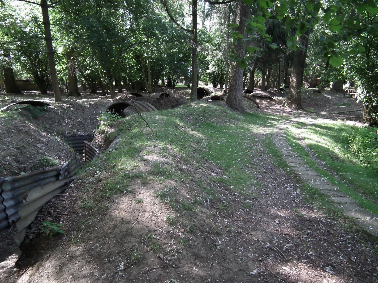
Perhaps of more interest than the crater are the trenches -- real ones -- that were left behind.
Pretend for a moment the trees aren't there
Imagine living, eating & sleeping in here
By the way, it was here that the flamethrower was first ever used in military combat, at 0315 on July 30, 1915.


There aren't a lot of trenches still left. There are also some on Hill 62, also referred to as Mount Sorrell.
A typical zig zag British trench
Muddy to me, probably dry to someone back then


However at Hill 62, you also get to see what artillery shell holes looked like, because they are still here and not filled in.
Again, for a moment, imagine the trees are not there
They are literally a step apart
How many hit the trenches themselves?
Hill 62/Mount Sorrell and the surrounding area (Sanctuary Wood, which wasn't a wood any more) was the site of a fierce German offensive in May 1915, an offensive stopped by the Canadians. The Germans took Hill 62 (one Canadian regiment lost 637 out of 680 men, the PPCLI was overrun and were shooting both directions), but the Canadians took most of it back, holding the front line for almost a year. And this results in another Canadian memorial.
The memorial from the Hill 62 trenches
Ypres, a mere 4 km away
You may note that all the Canadian memorials are surrounded by maple trees.


Just north of Ypres lies an Advanced Dressing Station...
The bunkers of the ADS
...the 2nd line of medical care beyond the front line. A young Canadian doctor was stationed here during the 2nd Battle of Ypres (the one with the gas attacks at Kitchener Wood). In 3 days he had witnessed a force of 10,000 Canadians suffer 6,000 casualties. One of his patients, who was also a friend, received a direct hit from an artillery shell. Reading the last words in his friend's diary, our doctor was moved to write a poem.
In Flanders Fields, the poppies blow
King Albert memorial to John McCrae
Inside one of the ADS bunkers
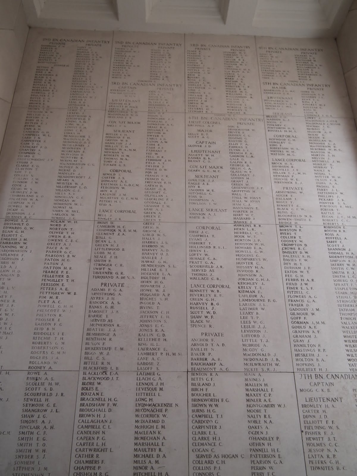
At 8:00 PM every day, every day since 1927 (with a break only for WW2), a ceremony marking all this tragedy occurs under the Menin Gate in Ypres. Being a walled city, the Menin Gate is one of the only ways out of the city, and given that it leads directly to the battlefields, it was through here most soldiers passed. In this little gate...
Menin Gate, from the Ypres side
...are commemorated yet another 55,000 soldiers with no known grave, in panel after panel of names, sorted by regiment.
The inside of the gate
Lots of names
They seem to go on forever
There are a lot of Canadian names.
A lot of names
A whole lot of names
Nowhere near all of the Canadian names
The ceremony is stirring to say the least. It starts with the playing of the "Last Post", and closes with the "Reveille" by Buglers of the Last Post Association. This video clip (I'm an awful film maker) should give you a flavour of the ceremony, the gate and the crowd that night, a typical night with some 1,000 people in attendance.


We rode 63 km around the edge of the battle lines and saw less than 10% of the cemeteries, memorials and markers that are within a 30 min drive of Ypres. We visited incredible museums, some great, some full of junk, showing the weapons, life in the bunkers, life in the trenches, filled with the sounds and the smells of the battlefield that the soldiers endured for 4 years. I have tons of photos of it all, but they don't add value to this story. It took us 20 min to bike across a strip of ground that took the Allied forces 4 months to fight their way across on one particular occasion. Farmers today continue to unearth fragments of war. The still-charged gas canisters they find are stockpiled because they still don't know how to dispose of them.


Our ride only served to hammer home the tragedy of it all. Poet and philosopher George Santayana said "Those who cannot remember the past are condemned to repeat it."


Let us never forget, and let us not do this again.
Tombs of the unknown